
Faire un don
Équipez-vous pour votre prochaine aventure :
En tant que Partenaire Amazon, ce site perçoit une commission sur les achats éligibles sans surcoût pour vous.
Carte topographique Thorp
Cliquez sur la carte pour afficher l’altitude.
Faire un don
Équipez-vous pour votre prochaine aventure :
En tant que Partenaire Amazon, ce site perçoit une commission sur les achats éligibles sans surcoût pour vous.
Thorp
The town of Thorp is 100 miles (160 km) east of Seattle, 8 miles (13 km) northwest of Ellensburg, and 17 miles (27 km) southeast of Cle Elum. It is located at the narrow west end of the Kittitas Valley, where high elevation forests of the Cascade Range give way to cattle ranches surrounded by farmlands noted for timothy hay, alfalfa, vegetables, and fruit production.
Faire un don
Équipez-vous pour votre prochaine aventure :
En tant que Partenaire Amazon, ce site perçoit une commission sur les achats éligibles sans surcoût pour vous.
À propos de cette carte
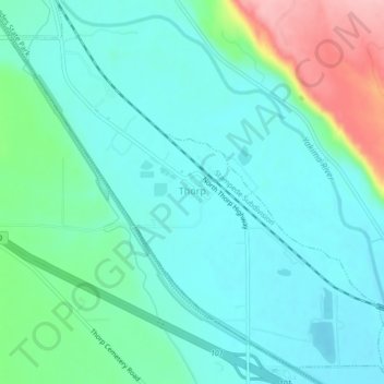
Nom : Carte topographique Thorp, altitude, relief.
Lieu : Thorp, Kittitas County, Washington, United States (47.05327 -120.69378 47.08248 -120.64984)
Altitude moyenne : 521 m
Altitude minimum : 486 m
Altitude maximum : 636 m
Faire un don
Équipez-vous pour votre prochaine aventure :
En tant que Partenaire Amazon, ce site perçoit une commission sur les achats éligibles sans surcoût pour vous.
Autres cartes topographiques
Cliquez sur une carte pour visualiser sa topographie, son altitude et son relief.
Cathedral Rock
United States > Washington > Kittitas County
Cathedral Rock is an intrusive andesite volcanic complex. The Alpine Lakes Wilderness features some of the most rugged topography in the Cascade Range with craggy peaks and ridges, deep glacial valleys, and granite walls spotted with over 700 mountain lakes. Geological events occurring many years ago created…
Altitude moyenne : 1.547 m
Faire un don
Équipez-vous pour votre prochaine aventure :
En tant que Partenaire Amazon, ce site perçoit une commission sur les achats éligibles sans surcoût pour vous.
Cathedral Rock
United States > Washington > Kittitas County
Cathedral Rock is an intrusive andesite volcanic complex. The Alpine Lakes Wilderness features some of the most rugged topography in the Cascade Range with craggy peaks and ridges, deep glacial valleys, and granite walls spotted with over 700 mountain lakes. Geological events occurring many years ago created…
Altitude moyenne : 1.547 m