
Faire un don
Équipez-vous pour votre prochaine aventure :
En tant que Partenaire Amazon, ce site perçoit une commission sur les achats éligibles sans surcoût pour vous.
Carte topographique Borgloh
Cliquez sur la carte pour afficher l’altitude.
Faire un don
Équipez-vous pour votre prochaine aventure :
En tant que Partenaire Amazon, ce site perçoit une commission sur les achats éligibles sans surcoût pour vous.
À propos de cette carte
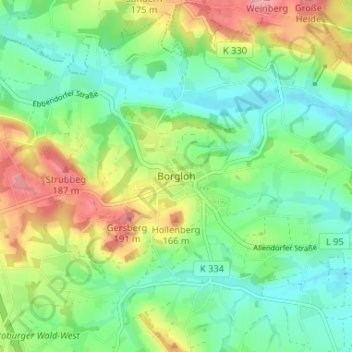
Nom : Carte topographique Borgloh, altitude, relief.
Altitude moyenne : 127 m
Altitude minimum : 86 m
Altitude maximum : 201 m
Faire un don
Équipez-vous pour votre prochaine aventure :
En tant que Partenaire Amazon, ce site perçoit une commission sur les achats éligibles sans surcoût pour vous.
Autres cartes topographiques
Cliquez sur une carte pour visualiser sa topographie, son altitude et son relief.
Bad Essen
Germany > Lower Saxony > Landkreis Osnabrück
The town of Bad Essen is on the North German Plains, because of the transition of the low mountain range to the plains. The Wiehengebirge Range covers approximately the southern third of the town and reaches an elevation of 211m above sea level. The highest point of the Wiehengebirge Range is on the black…
Altitude moyenne : 79 m
Faire un don
Équipez-vous pour votre prochaine aventure :
En tant que Partenaire Amazon, ce site perçoit une commission sur les achats éligibles sans surcoût pour vous.
Georgsmarienhütte
Germany > Lower Saxony > Landkreis Osnabrück > Georgsmarienhütte
Altitude moyenne : 133 m
Faire un don
Équipez-vous pour votre prochaine aventure :
En tant que Partenaire Amazon, ce site perçoit une commission sur les achats éligibles sans surcoût pour vous.