
Faire un don
Équipez-vous pour votre prochaine aventure :
En tant que Partenaire Amazon, ce site perçoit une commission sur les achats éligibles sans surcoût pour vous.
Carte topographique Norwood
Cliquez sur la carte pour afficher l’altitude.
Faire un don
Équipez-vous pour votre prochaine aventure :
En tant que Partenaire Amazon, ce site perçoit une commission sur les achats éligibles sans surcoût pour vous.
À propos de cette carte
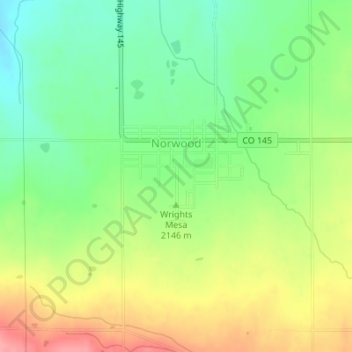
Nom : Carte topographique Norwood, altitude, relief.
Lieu : Norwood, San Miguel County, Colorado, 81325, United States (38.12222 -108.29955 38.13377 -108.28478)
Altitude moyenne : 2.148 m
Altitude minimum : 2.105 m
Altitude maximum : 2.203 m
Faire un don
Équipez-vous pour votre prochaine aventure :
En tant que Partenaire Amazon, ce site perçoit une commission sur les achats éligibles sans surcoût pour vous.
Autres cartes topographiques
Cliquez sur une carte pour visualiser sa topographie, son altitude et son relief.
Telluride
United States > Colorado > San Miguel County
Telluride has an elevation of 8,750 feet (2,670 m) in an isolated spot in Southwest Colorado. From the west, Colorado Route 145 is the most common way into Telluride; two other passes enter the town, Imogene Pass and Black Bear Pass.
Altitude moyenne : 3.125 m
Faire un don
Équipez-vous pour votre prochaine aventure :
En tant que Partenaire Amazon, ce site perçoit une commission sur les achats éligibles sans surcoût pour vous.
Telluride
United States > Colorado > San Miguel County
Telluride has an elevation of 8,750 feet (2,670 m) in an isolated spot in Southwest Colorado. From the west, Colorado Route 145 is the most common way into Telluride; two other passes enter the town, Imogene Pass and Black Bear Pass.
Altitude moyenne : 3.125 m
Faire un don
Équipez-vous pour votre prochaine aventure :
En tant que Partenaire Amazon, ce site perçoit une commission sur les achats éligibles sans surcoût pour vous.
Telluride
United States > Colorado > San Miguel County > Telluride
Telluride has an elevation of 8,750 feet (2,670 m) in an isolated spot in Southwest Colorado. From the west, Colorado Route 145 is the most common way into Telluride; two other passes enter the town, Imogene Pass and Black Bear Pass.
Altitude moyenne : 3.246 m
Faire un don
Équipez-vous pour votre prochaine aventure :
En tant que Partenaire Amazon, ce site perçoit une commission sur les achats éligibles sans surcoût pour vous.