
Carte topographique Santa Magdalena
Cliquez sur la carte pour afficher l’altitude.
À propos de cette carte
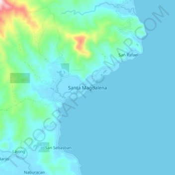
Nom : Carte topographique Santa Magdalena, altitude, relief.
Lieu : Santa Magdalena, Sorsogon, Bicol Region, 4709, Philippines (12.60633 124.06791 12.68633 124.14791)
Altitude moyenne : 55 m
Altitude minimum : -1 m
Altitude maximum : 504 m
Autres cartes topographiques
Cliquez sur une carte pour visualiser sa topographie, son altitude et son relief.
Bulusan Lake
Philippines > Sorsogon > San Roque
Lake Bulusan is a lake on Luzon Island in the Philippines. It lies at the heart of Bulusan Volcano National Park which covers a land area of 3,672 hectares (9,070 acres). It has an elevation of 360 metres (1,180 ft) and is located on the southeast flank of Mount Bulusan, an active volcano.
Altitude moyenne : 382 m