
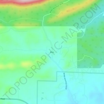
Carte topographique Bear
Carte interactive
Cliquez sur la carte pour afficher l’altitude.
À propos de cette carte
Nom : Carte topographique Bear, altitude, relief.
Lieu : Bear, Garland County, Arkansas, 71968, United States (34.51453 -93.29380 34.55453 -93.25380)
Altitude moyenne : 216 m
Altitude minimum : 154 m
Altitude maximum : 405 m
Autres cartes topographiques
Cliquez sur une carte pour visualiser sa topographie, son altitude et son relief.
Hot Springs Village
United States > Arkansas > Garland County
Hot Springs Village, Garland County, Arkansas, 71909, United States
Altitude moyenne : 226 m
Hot Springs National Park
United States > Arkansas > Garland County > Hot Springs
Hot Springs National Park, Hot Springs, Garland County, Arkansas, 71901, United States
Altitude moyenne : 227 m
Hot Springs
United States > Arkansas > Garland County
Hot Springs, Garland County, Arkansas, United States
Altitude moyenne : 172 m
Piney
United States > Arkansas > Garland County > Hot Springs
Piney, Hot Springs, Garland County, Arkansas, United States
Altitude moyenne : 146 m
Sunshine
United States > Arkansas > Garland County
Sunshine, Garland County, Arkansas, 71968, United States
Altitude moyenne : 155 m
Crystal Springs
United States > Arkansas > Garland County
Crystal Springs, Garland County, Arkansas, United States
Altitude moyenne : 227 m
Buckville Public Use Area
United States > Arkansas > Garland County
Buckville Public Use Area, Garland County, Arkansas, United States
Altitude moyenne : 185 m
Rockwell
United States > Arkansas > Garland County > Rockwell
Rockwell, Garland County, Arkansas, United States
Altitude moyenne : 138 m
Pleasant Hill
United States > Arkansas > Garland County
Pleasant Hill, Garland County, Arkansas, United States
Altitude moyenne : 152 m
Lake Hamilton
United States > Arkansas > Garland County > Hot Springs
Lake Hamilton, Hot Springs, Garland County, Arkansas, United States
Altitude moyenne : 130 m
Fountain Lake
United States > Arkansas > Garland County
Fountain Lake, Garland County, Arkansas, 71901, United States
Altitude moyenne : 165 m
Mountain Pine
United States > Arkansas > Garland County
Mountain Pine, Garland County, Arkansas, United States
Altitude moyenne : 159 m
Royal
United States > Arkansas > Garland County
Royal, Garland County, Arkansas, 71968, United States
Altitude moyenne : 160 m
Lonsdale
United States > Arkansas > Garland County
Lonsdale, Garland County, Arkansas, 72087, United States
Altitude moyenne : 149 m
Mountain Valley
United States > Arkansas > Garland County > Hot Springs Village > Mountain Valley
Mountain Valley, Hot Springs Village, Garland County, Arkansas, 71909, United States
Altitude moyenne : 248 m
Jessieville
United States > Arkansas > Garland County
Jessieville, Garland County, Arkansas, 71910, United States
Altitude moyenne : 238 m
Blue Springs
United States > Arkansas > Garland County > Blue Springs
Blue Springs, Garland County, Arkansas, 71910, United States
Altitude moyenne : 256 m
Pearcy
United States > Arkansas > Garland County
Pearcy, Garland County, Arkansas, United States
Altitude moyenne : 191 m
Hot Springs
United States > Arkansas > Garland County > Hot Springs
Hot Springs, Garland County, Arkansas, 71901, United States
Altitude moyenne : 187 m