
Carte topographique Ingham County
Carte interactive
Cliquez sur la carte pour afficher l’altitude.
À propos de cette carte
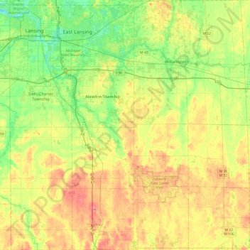
Nom : Carte topographique Ingham County, altitude, relief.
Lieu : Ingham County, Michigan, USA (42.42146 -84.60387 42.77664 -84.14060)
Altitude moyenne : 278 m
Altitude minimum : 246 m
Altitude maximum : 321 m
Autres cartes topographiques
Cliquez sur une carte pour visualiser sa topographie, son altitude et son relief.
East Lansing
USA > Michigan > East Lansing
East Lansing, Ingham County, Michigan, USA
Altitude moyenne : 261 m
Isle Royale National Park
Isle Royale National Park, Greenstone Ridge Trail, Houghton Township, Keweenaw County, Michigan, USA
Altitude moyenne : 189 m