
Carte topographique Mobile
Carte interactive
Cliquez sur la carte pour afficher l’altitude.
À propos de cette carte
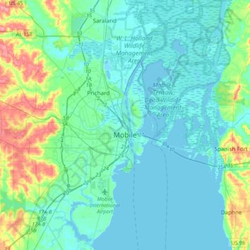
Nom : Carte topographique Mobile, altitude, relief.
Lieu : Mobile, Mobile County, Alabama, United States of America (30.56037 -88.22125 30.84346 -87.95662)
Altitude moyenne : 14 m
Altitude minimum : -2 m
Altitude maximum : 76 m
Mobile is located in the southwestern corner of the U.S. state of Alabama. According to the United States Census Bureau, the city has a total area of 159.4 square miles (413 km2), with 117.9 square miles (305 km2) of it being land, and 41.5 square miles (107.5 km2), or 26.1% of the total, being covered by water. The elevation in Mobile ranges from 10 feet (3 m) on Water Street in downtown to 211 feet (64 m) at the Mobile Regional Airport.
Autres cartes topographiques
Cliquez sur une carte pour visualiser sa topographie, son altitude et son relief.
Spanish River
United States of America > Alabama > Mobile
Spanish River, Mobile, Mobile County, Alabama, 36577, United States of America
Altitude moyenne : 3 m