
Carte topographique Campsall
Cliquez sur la carte pour afficher l’altitude.
Campsall
Campsall is a village and former civil parish, now in the parish of Norton, in the Doncaster district, in the county of South Yorkshire, England. It lies 7 miles (11 km) to the north-west of Doncaster, at an elevation of around 50 feet above sea level. The village contains Campsall Country Park. The village falls within the Norton & Askern ward of Doncaster Council and the House of Commons constituency of Doncaster North. The Parish is situated on the “Magnesian Limestone Belt”, a landscape feature formed by a narrow north–south trending escarpment. The Magnesian Limestone Belt is typified by well drained and fertile soils which were ideal for agriculture and the establishment of settlements like Campsall. Before the industrial revolution, the area to the east was occupied by the inaccessible and waterlogged marshes of the Humberhead Levels, whilst to the west was the Barnsdale Forest, an area associated with the legend of Robin Hood and various outlaws and bandits who preyed upon travellers on the Great North Road. In 1931 the parish had a population of 260.
À propos de cette carte
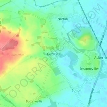
Nom : Carte topographique Campsall, altitude, relief.
Altitude moyenne : 24 m
Altitude minimum : 3 m
Altitude maximum : 76 m
Autres cartes topographiques
Cliquez sur une carte pour visualiser sa topographie, son altitude et son relief.