
Carte topographique Mount Augusta
Carte interactive
Cliquez sur la carte pour afficher l’altitude.
À propos de cette carte
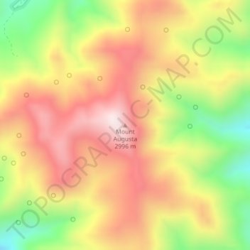
Nom : Carte topographique Mount Augusta, altitude, relief.
Lieu : Mount Augusta, Churchill County, Nevada, USA (39.53959 -117.91851 39.53969 -117.91841)
Altitude moyenne : 2.752 m
Altitude minimum : 2.419 m
Altitude maximum : 3.022 m
Autres cartes topographiques
Cliquez sur une carte pour visualiser sa topographie, son altitude et son relief.
Boulder City
USA > Nevada > Boulder City
Boulder City, Clark County, Nevada, 89005, USA
Altitude moyenne : 659 m
Whistler Mountain
Whistler Mountain, Eureka County, Nevada, USA
Altitude moyenne : 2.211 m
Wheeler Peak Glacier
Wheeler Peak Glacier, Bristlecone and Glacier Trail, White Pine County, Nevada, USA
Altitude moyenne : 3.500 m
Red Rock Canyon National Conservation Area
USA > Nevada > Mountain Springs
Red Rock Canyon National Conservation Area, NV 160, Mountain Springs, Clark County, Nevada, USA
Altitude moyenne : 1.361 m
Ruby Mountains
Ruby Mountains, National Forest Development Road 343 Trail, Elko County, Nevada, USA
Altitude moyenne : 1.962 m
River Mountains Loop Trail
USA > Nevada > Boulder City
River Mountains Loop Trail, Boulder City, Clark County, Nevada, 89005, USA
Altitude moyenne : 756 m
Snake Range
Snake Range, Great Basin National Park, White Pine County, Nevada, USA
Altitude moyenne : 1.984 m
Jeff Davis Peak
Jeff Davis Peak, White Pine County, Nevada, USA
Altitude moyenne : 3.432 m
North Las Vegas
USA > Nevada > North Las Vegas
North Las Vegas, Clark County, Nevada, USA
Altitude moyenne : 682 m