
Carte topographique Opotiki
Carte interactive
Cliquez sur la carte pour afficher l’altitude.
À propos de cette carte
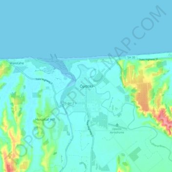
Nom : Carte topographique Opotiki, altitude, relief.
Altitude moyenne : 14 m
Altitude minimum : 0 m
Altitude maximum : 104 m
Autres cartes topographiques
Cliquez sur une carte pour visualiser sa topographie, son altitude et son relief.
Parinui
New Zealand > Bay of Plenty > Ōpōtiki District
Parinui, Ōpōtiki District, Bay of Plenty, 3162, New Zealand
Altitude moyenne : 67 m
Whitianga
New Zealand > Bay of Plenty > Ōpōtiki District
Whitianga, Ōpōtiki District, Bay of Plenty, 3162, New Zealand
Altitude moyenne : 42 m
Papamoa
New Zealand > Bay of Plenty > Ōpōtiki District
Papamoa, Ōpōtiki District, Bay of Plenty, New Zealand
Altitude moyenne : 544 m
Ohiwa
New Zealand > Bay of Plenty > Ōpōtiki District
Ohiwa, Ōpōtiki District, Bay of Plenty, 3198, New Zealand
Altitude moyenne : 11 m
Kaharoa
New Zealand > Bay of Plenty > Ōpōtiki District
Kaharoa, Ōpōtiki District, Bay of Plenty, New Zealand
Altitude moyenne : 721 m