
Faire un don
Équipez-vous pour votre prochaine aventure :
En tant que Partenaire Amazon, ce site perçoit une commission sur les achats éligibles sans surcoût pour vous.
Carte topographique Willamette River
Cliquez sur la carte pour afficher l’altitude.
Faire un don
Équipez-vous pour votre prochaine aventure :
En tant que Partenaire Amazon, ce site perçoit une commission sur les achats éligibles sans surcoût pour vous.
Willamette River
The Willamette River drains a region of 11,478 square miles (29,730 km2), which is 12 percent of the total area of Oregon. Bounded by the Coast Range to the west and the Cascade Range to the east, the river basin is about 180 miles (290 km) long and 100 miles (160 km) wide. Elevations within the watershed range from 10,495 feet (3,199 m) at Mount Jefferson in the Cascade Range to 10 feet (3.0 m) at the mouth on the Columbia River. Watersheds bordering the Willamette River basin are those of the Little Deschutes River to the southeast, the Deschutes River to the east, and the Sandy River to the northeast; the North Umpqua and Umpqua rivers to the south; coastal rivers including (from south to north) the Siuslaw, the Alsea, the Yaquina, the Siletz, the Nestucca, the Trask, and the Wilson to the west; the Nehalem and the Clatskanie to the northwest, and the Columbia River to the north.
Faire un don
Équipez-vous pour votre prochaine aventure :
En tant que Partenaire Amazon, ce site perçoit une commission sur les achats éligibles sans surcoût pour vous.
À propos de cette carte
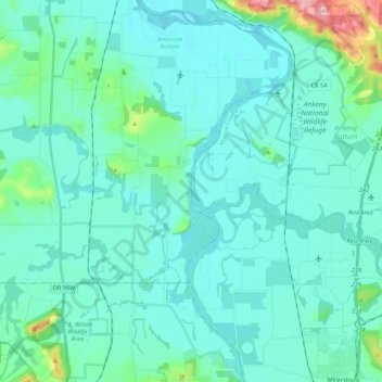
Nom : Carte topographique Willamette River, altitude, relief.
Lieu : Willamette River, Polk County, Oregon, United States (44.67991 -123.18023 44.83492 -123.09000)
Altitude moyenne : 72 m
Altitude minimum : 40 m
Altitude maximum : 290 m
Faire un don
Équipez-vous pour votre prochaine aventure :
En tant que Partenaire Amazon, ce site perçoit une commission sur les achats éligibles sans surcoût pour vous.
Autres cartes topographiques
Cliquez sur une carte pour visualiser sa topographie, son altitude et son relief.