
Carte topographique Big Sky
Carte interactive
Cliquez sur la carte pour afficher l’altitude.
À propos de cette carte
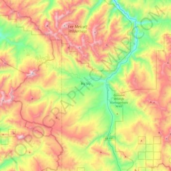
Nom : Carte topographique Big Sky, altitude, relief.
Lieu : Big Sky, Gallatin County, Montana, United States (45.13076 -111.49439 45.37939 -111.03817)
Altitude moyenne : 2.435 m
Altitude minimum : 1.689 m
Altitude maximum : 3.382 m
This climatic region is typified by large seasonal temperature differences, with warm to hot summers and cold (sometimes severely cold) winters. According to the Köppen Climate Classification system, Big Sky has a borderline humid continental (Dfb) / alpine subarctic climate (Dfc). for most of the area, but the lower elevations may be closer to a dry continental climate.
Autres cartes topographiques
Cliquez sur une carte pour visualiser sa topographie, son altitude et son relief.
Bozeman
United States > Montana > Gallatin County
Bozeman, Gallatin County, Montana, United States
Altitude moyenne : 1.495 m
Belgrade
United States > Montana > Gallatin County
Belgrade, Gallatin County, Montana, 59714, United States
Altitude moyenne : 1.355 m
Lightning Lake
United States > Montana > Gallatin County
Lightning Lake, Gallatin County, Montana, United States
Altitude moyenne : 2.690 m
Bozeman
United States > Montana > Gallatin County > Bozeman
Bozeman, Gallatin County, Montana, 59715, United States
Altitude moyenne : 1.679 m
Springhill
United States > Montana > Gallatin County > Springhill
Springhill, Gallatin County, Montana, United States
Altitude moyenne : 1.491 m