
Faire un don
Équipez-vous pour votre prochaine aventure :
En tant que Partenaire Amazon, ce site perçoit une commission sur les achats éligibles sans surcoût pour vous.
Carte topographique Poage Lake
Cliquez sur la carte pour afficher l’altitude.
Faire un don
Équipez-vous pour votre prochaine aventure :
En tant que Partenaire Amazon, ce site perçoit une commission sur les achats éligibles sans surcoût pour vous.
À propos de cette carte
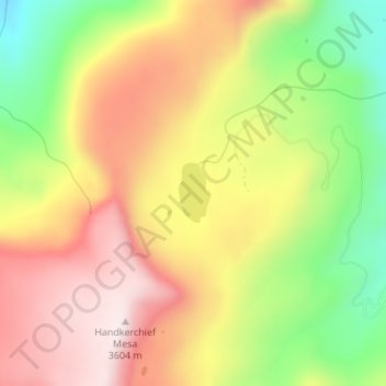
Nom : Carte topographique Poage Lake, altitude, relief.
Lieu : Poage Lake, Rio Grande County, Colorado, United States (37.49747 -106.64449 37.50166 -106.64166)
Altitude moyenne : 3.369 m
Altitude minimum : 3.094 m
Altitude maximum : 3.607 m
Faire un don
Équipez-vous pour votre prochaine aventure :
En tant que Partenaire Amazon, ce site perçoit une commission sur les achats éligibles sans surcoût pour vous.
Autres cartes topographiques
Cliquez sur une carte pour visualiser sa topographie, son altitude et son relief.
Del Norte
United States > Colorado > Rio Grande County
Relatively-speaking, it is located where the Rio Grande leaves the San Juan Mountains and enters the San Luis Valley, near its confluences with Pinos Creek and San Francisco Creek, respectively. Due to its location on the western edge of the valley, a variety of climates, vegetation regions, and ecosystems…
Altitude moyenne : 2.416 m
Faire un don
Équipez-vous pour votre prochaine aventure :
En tant que Partenaire Amazon, ce site perçoit une commission sur les achats éligibles sans surcoût pour vous.