
Faire un don
Équipez-vous pour votre prochaine aventure :
En tant que Partenaire Amazon, ce site perçoit une commission sur les achats éligibles sans surcoût pour vous.
Carte topographique Drake Crossing
Cliquez sur la carte pour afficher l’altitude.
Faire un don
Équipez-vous pour votre prochaine aventure :
En tant que Partenaire Amazon, ce site perçoit une commission sur les achats éligibles sans surcoût pour vous.
À propos de cette carte
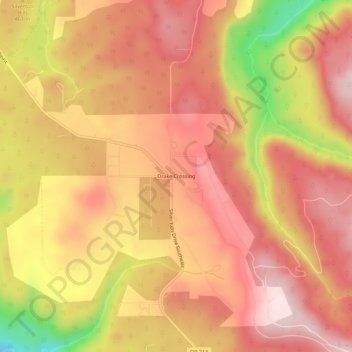
Nom : Carte topographique Drake Crossing, altitude, relief.
Lieu : Drake Crossing, Marion County, Oregon, United States (44.90596 -122.67592 44.94596 -122.63592)
Altitude moyenne : 473 m
Altitude minimum : 231 m
Altitude maximum : 597 m
Faire un don
Équipez-vous pour votre prochaine aventure :
En tant que Partenaire Amazon, ce site perçoit une commission sur les achats éligibles sans surcoût pour vous.
Autres cartes topographiques
Cliquez sur une carte pour visualiser sa topographie, son altitude et son relief.
Salem
United States > Oregon > Marion County
Salem is situated in the heart of the Willamette Valley and features a varied topography shaped by its proximity to notable geological formations. The city itself is primarily located at an elevation of around 177 feet (54 meters), but it spans a range from approximately 120 to 800 feet (37 to 244 meters)…
Altitude moyenne : 96 m
Silverton
United States > Oregon > Marion County
Silverton's elevation is between 200 and 250 feet (61 and 76 m) above mean sea level with the steep-sided, heavily-wooded Waldo Hills to the south rising an additional 200 feet (61 m). The agricultural richness of the environs is due to massive and repeated floods from prehistoric Lake Missoula in western…
Altitude moyenne : 103 m
Faire un don
Équipez-vous pour votre prochaine aventure :
En tant que Partenaire Amazon, ce site perçoit une commission sur les achats éligibles sans surcoût pour vous.
Faire un don
Équipez-vous pour votre prochaine aventure :
En tant que Partenaire Amazon, ce site perçoit une commission sur les achats éligibles sans surcoût pour vous.
Salem
United States > Oregon > Marion County
Elevation within the city limits ranges from about 120 to 800 feet (37 to 244 m). Salem contains the volcanic Salem Hills in the south and is sandwiched by the 1,000 ft (300 m) Eola Hills directly to the west and the 600 ft (180 m) Waldo Hills to the east. Northern and eastern Salem are less hilly. South and…
Altitude moyenne : 96 m
Detroit Lake
United States > Oregon > Marion County > Detroit
The water level fluctuates with snow pack, precipitation, and the water consumption of Salem, and surrounding areas. At low pool, it has a surface elevation of 1,450 feet (440 m); at the full pool season—typically May 1 to September 1—it can raise up 119 feet (36 m) to a water elevation of 1,569 feet (478 m).
Altitude moyenne : 799 m
Salem
United States > Oregon > Marion County
Elevation within the city limits ranges from about 120 to 800 feet (37 to 244 m). Salem contains the volcanic Salem Hills in the south and is sandwiched by the 1,000 ft (300 m) Eola Hills directly to the west and the 600 ft (180 m) Waldo Hills to the east. Northern and eastern Salem are less hilly. South and…
Altitude moyenne : 96 m
Faire un don
Équipez-vous pour votre prochaine aventure :
En tant que Partenaire Amazon, ce site perçoit une commission sur les achats éligibles sans surcoût pour vous.
Faire un don
Équipez-vous pour votre prochaine aventure :
En tant que Partenaire Amazon, ce site perçoit une commission sur les achats éligibles sans surcoût pour vous.
Silverton
United States > Oregon > Marion County
Silverton's elevation is between 200 and 250 feet (61 and 76 m) above mean sea level with the steep-sided, heavily-wooded Waldo Hills to the south rising an additional 200 feet (61 m). The agricultural richness of the environs is due to massive and repeated floods from prehistoric Lake Missoula in western…
Altitude moyenne : 103 m