
Carte topographique Lawrencetown
Carte interactive
Cliquez sur la carte pour afficher l’altitude.
À propos de cette carte
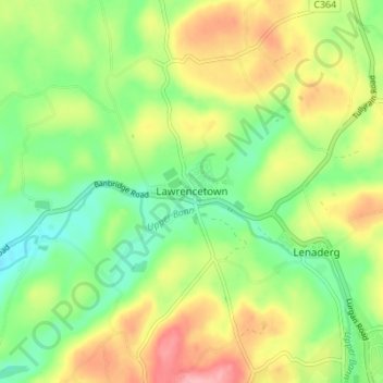
Nom : Carte topographique Lawrencetown, altitude, relief.
Altitude moyenne : 72 m
Altitude minimum : 24 m
Altitude maximum : 137 m
Autres cartes topographiques
Cliquez sur une carte pour visualiser sa topographie, son altitude et son relief.
Newry
United Kingdom > Northern Ireland > County Down
Newry, County Down, Northern Ireland, United Kingdom
Altitude moyenne : 73 m
Dundonald
United Kingdom > Northern Ireland > County Down
Dundonald, County Down, Ulster, Northern Ireland, BT16 1RH, United Kingdom
Altitude moyenne : 80 m
Killough
United Kingdom > Northern Ireland > County Down
Killough, County Down, Ulster, Northern Ireland, BT30 7QQ, United Kingdom
Altitude moyenne : 7 m
Ballynahinch
United Kingdom > Northern Ireland > County Down > Ballynahinch
Ballynahinch, County Down, Ulster, Northern Ireland, BT24 8DN, United Kingdom
Altitude moyenne : 99 m
Saintfield
United Kingdom > Northern Ireland > County Down
Saintfield, County Down, Ulster, Northern Ireland, BT24 7AA, United Kingdom
Altitude moyenne : 87 m
County Down
United Kingdom > Northern Ireland > County Down
County Down, Northern Ireland, United Kingdom
Altitude moyenne : 65 m