
Carte topographique Jarrell
Cliquez sur la carte pour afficher l’altitude.
À propos de cette carte
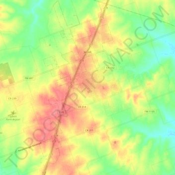
Nom : Carte topographique Jarrell, altitude, relief.
Lieu : Jarrell, Williamson County, Texas, United States (30.75265 -97.63773 30.85521 -97.58711)
Altitude moyenne : 252 m
Altitude minimum : 217 m
Altitude maximum : 286 m
Autres cartes topographiques
Cliquez sur une carte pour visualiser sa topographie, son altitude et son relief.
Georgetown
United States > Texas > Williamson County > Georgetown
The city is located on the northeastern edge of Texas Hill Country. Portions of Georgetown are located on either side of the Balcones Escarpment, a fault line in which the areas roughly east of IH-35 are flat and characterized by having black, fertile soils of the Blackland Prairie, and the west side of the…
Altitude moyenne : 228 m
Soil Conservation Service Site 12 Dam
United States > Texas > Williamson County > Type
Altitude moyenne : 173 m
Soil Conservation Service Site 12 Dam
United States > Texas > Williamson County > Type
Altitude moyenne : 173 m
Soil Conservation Service Site 12 Dam
United States > Texas > Williamson County > Type
Altitude moyenne : 173 m