
Carte topographique Tiger Bay
Carte interactive
Cliquez sur la carte pour afficher l’altitude.
À propos de cette carte
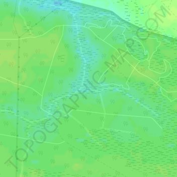
Nom : Carte topographique Tiger Bay, altitude, relief.
Lieu : Tiger Bay, Horry County, South Carolina, USA (33.81081 -78.86433 33.81159 -78.86112)
Altitude moyenne : 13 m
Altitude minimum : 5 m
Altitude maximum : 16 m
Autres cartes topographiques
Cliquez sur une carte pour visualiser sa topographie, son altitude et son relief.
Little River
Little River, Horry County, South Carolina, 28467, USA
Altitude moyenne : 1 m
Murrells Inlet
Murrells Inlet, Georgetown County, South Carolina, 29576, USA
Altitude moyenne : -1 m
Lake Greenwood
USA > South Carolina > Lota
Lake Greenwood, Sparrow Road, Lota, Greenwood County, South Carolina, 29649, USA
Altitude moyenne : 163 m
Francis Marion National Forest
USA > South Carolina > Washington
Francis Marion National Forest, Horse Island Road, Washington, Berkeley County, South Carolina, 29453, USA
Altitude moyenne : 6 m
Stono River
USA > South Carolina > Charleston
Stono River, Charleston, Charleston County, South Carolina, 29407, USA
Altitude moyenne : 3 m
Saluda River
USA > South Carolina > West Columbia
Saluda River, West Columbia, Richland County, South Carolina, 29169, USA
Altitude moyenne : 67 m
Edisto River
Edisto River, Colleton County, South Carolina, 29274, USA
Altitude moyenne : 14 m
Wateree
USA > South Carolina > Wateree
Wateree, Richland County, South Carolina, USA
Altitude moyenne : 33 m
Congaree National Park
USA > South Carolina > Totness
Congaree National Park, Hedrick Lane, Totness, Calhoun County, South Carolina, USA
Altitude moyenne : 55 m
Litchfield Beach
USA > South Carolina > Litchfield Beach
Litchfield Beach, Georgetown County, South Carolina, 29585, USA
Altitude moyenne : 2 m
Little Mountain
Little Mountain, Newberry County, South Carolina, 29075, USA
Altitude moyenne : 170 m
Hunting Island State Park
USA > South Carolina > Oceanmarsh Subdivision
Hunting Island State Park, Oceanmarsh Subdivision, Beaufort County, South Carolina, USA
Altitude moyenne : 1 m
Lugoff
USA > South Carolina > Lugoff
Lugoff, Kershaw County, South Carolina, 29078, USA
Altitude moyenne : 70 m
Wadmalaw Island
USA > South Carolina > Wadmalaw Island
Wadmalaw Island, Charleston County, South Carolina, 24449, USA
Altitude moyenne : 2 m
J. Strom Thurmond Reservoir
J. Strom Thurmond Reservoir, Split Oak Road, McCormick County, South Carolina, USA
Altitude moyenne : 122 m
Newberry
USA > South Carolina > Newberry
Newberry, Newberry County, South Carolina, 29108, USA
Altitude moyenne : 156 m
Shalimar
USA > South Carolina > Shalimar
Shalimar, Cherokee County, South Carolina, 29341, USA
Altitude moyenne : 229 m
Joanna
USA > South Carolina > Joanna
Joanna, Laurens County, South Carolina, 29351, USA
Altitude moyenne : 172 m
Scotia
USA > South Carolina > Scotia
Scotia, Hampton County, South Carolina, 29939, USA
Altitude moyenne : 30 m
Stone Lake
USA > South Carolina > Stone Lake
Stone Lake, Greenville County, South Carolina, 29609, USA
Altitude moyenne : 305 m
Carr Creek
Carr Creek, Georgetown County, South Carolina, USA
Altitude moyenne : 2 m
Caesars Head
Caesars Head, Pickens County, South Carolina, USA
Altitude moyenne : 838 m
Abbeville
USA > South Carolina > Abbeville
Abbeville, Abbeville County, South Carolina, USA
Altitude moyenne : 174 m
Hollywood Hills
USA > South Carolina > Hollywood Hills
Hollywood Hills, Richland County, South Carolina, 29203, USA
Altitude moyenne : 82 m
Red Bluff Crossroads
USA > South Carolina > Red Bluff Crossroads
Red Bluff Crossroads, Horry County, South Carolina, USA
Altitude moyenne : 7 m
Pinckney Island
Pinckney Island, Beaufort County, South Carolina, 29926, USA
Altitude moyenne : 3 m
Talatha Gardens
USA > South Carolina > Talatha Gardens
Talatha Gardens, Aiken County, South Carolina, 29803, USA
Altitude moyenne : 132 m
Lake Conestee Nature Park
USA > South Carolina > Augusta Acres
Lake Conestee Nature Park, Heron Spur, Augusta Acres, Greenville County, South Carolina, 29636, USA
Altitude moyenne : 261 m
State Park
USA > South Carolina > State Park
State Park, Richland County, South Carolina, 29203S, USA
Altitude moyenne : 96 m
South Carolina Botanical Garden
USA > South Carolina > Clemson
South Carolina Botanical Garden, 150, Clemson, Pickens County, South Carolina, 29634, USA
Altitude moyenne : 236 m
Wambaw Swamp
USA > South Carolina > Thompson Corner
Wambaw Swamp, Victor Lincoln Road, Thompson Corner, Charleston County, South Carolina, USA
Altitude moyenne : 5 m
Hidden Creek
USA > South Carolina > Hidden Creek
Hidden Creek, Greenville County, South Carolina, 29644, USA
Altitude moyenne : 259 m
Colonial Dorchester State Historic Site
USA > South Carolina > Waters Edge
Colonial Dorchester State Historic Site, Waters Edge, Dorchester County, South Carolina, USA
Altitude moyenne : 7 m
Cedar Falls Dam
Cedar Falls Dam, Greenville County, South Carolina, USA
Altitude moyenne : 212 m
North Saluda River
North Saluda River, Greenville County, South Carolina, USA
Altitude moyenne : 368 m
Wagner Creek
USA > South Carolina > Mount Pleasant
Wagner Creek, Mount Pleasant, Charleston County, South Carolina, 29466, USA
Altitude moyenne : 3 m
Dreher Island
Dreher Island, Newberry County, South Carolina, USA
Altitude moyenne : 129 m
Merrifield Park
USA > South Carolina > Merrifield Park
Merrifield Park, Greenville County, South Carolina, 29615, USA
Altitude moyenne : 296 m
Bond Swamp
Bond Swamp, Georgetown County, South Carolina, 02950, USA
Altitude moyenne : 6 m
Grenadier
USA > South Carolina > Grenadier
Grenadier, Lexington County, South Carolina, 29210, USA
Altitude moyenne : 74 m
Simmonsville
USA > South Carolina > Simmonsville
Simmonsville, Georgetown County, South Carolina, USA
Altitude moyenne : 5 m
Buck Shoals
Buck Shoals, Fairfield County, South Carolina, USA
Altitude moyenne : 95 m
Grassy Pond
USA > South Carolina > Grassy Pond
Grassy Pond, Cherokee County, South Carolina, 29341, USA
Altitude moyenne : 247 m
Little Wambaw Swamp
USA > South Carolina > Laurel Hill Plantation
Little Wambaw Swamp, Old Georgetown Road, Laurel Hill Plantation, Charleston County, South Carolina, 29458, USA
Altitude moyenne : 5 m
Sadlers Creek
Sadlers Creek, Anderson County, South Carolina, USA
Altitude moyenne : 218 m
Watkins Creek
Watkins Creek, Laurens County, South Carolina, USA
Altitude moyenne : 150 m
Big Shoals
Big Shoals, Spartanburg County, South Carolina, 29324, USA
Altitude moyenne : 210 m
Tugaloo Lake
USA > South Carolina > Battle Creek
Tugaloo Lake, Bull Sluice Road, Battle Creek, Oconee County, South Carolina, 29658, USA
Altitude moyenne : 402 m
Fogarty Creek
USA > South Carolina > Charleston
Fogarty Creek, Charleston, Berkeley County, South Carolina, USA
Altitude moyenne : 5 m
Silver Lake
USA > South Carolina > Silver Lake
Silver Lake, Lexington County, South Carolina, USA
Altitude moyenne : 57 m