
Carte topographique Mount Sungay
Carte interactive
Cliquez sur la carte pour afficher l’altitude.
À propos de cette carte
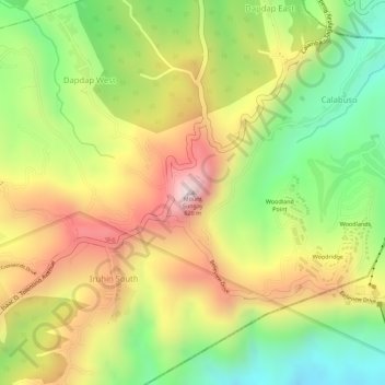
Nom : Carte topographique Mount Sungay, altitude, relief.
Altitude moyenne : 501 m
Altitude minimum : 264 m
Altitude maximum : 728 m
Mount Sungay is the eastern end of the Tagaytay Range, or more commonly known as the Tagaytay Ridge, a 32-kilometre (20 mi) ridge located at the southern part of the province with elevations averaging about 600 m (2,000 ft) above sea level. The ridge stretches west-southwest from Mount Sungay to Mount Batulao in Batangas province.
Autres cartes topographiques
Cliquez sur une carte pour visualiser sa topographie, son altitude et son relief.
Tagaytay Highlands
Philippines > Cavite > Tagaytay > Iruhin South
Tagaytay Highlands, Woodridge, Iruhin South, Tagaytay, Cavite, Calabarzon, 4120, Philippines
Altitude moyenne : 428 m
People's Park in the Sky
Philippines > Cavite > Tagaytay > Iruhin South
People's Park in the Sky, Woodland Point, Iruhin South, Tagaytay, Cavite, Calabarzon, 4120, Philippines
Altitude moyenne : 503 m