
Carte topographique Imphal East
Carte interactive
Cliquez sur la carte pour afficher l’altitude.
À propos de cette carte
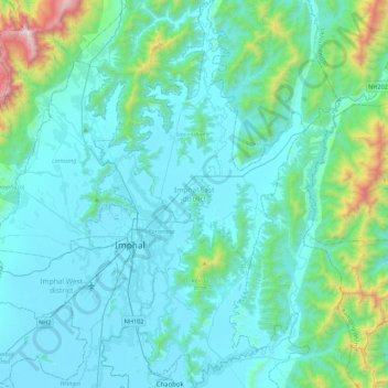
Nom : Carte topographique Imphal East, altitude, relief.
Lieu : Imphal East, Manipur, India (24.65151 93.89542 25.05120 94.13485)
Altitude moyenne : 982 m
Altitude minimum : 767 m
Altitude maximum : 2.498 m
Imphal East District came into existence on 18-06-1997 with its headquarters at Porompat occupying the eastern part of Imphal District. The total area of District is 497 km2. approximately. The District is situated at an altitude 790 metres above the M.S. Level. The climate of the District is salubrious and Monsoon is tropical. The minimum temperature goes down to 0.6 degree Celsius in winter and 41 degree Celsius in summer. It has no rail network and hence communication is entirely dependent on roads except Jiribam District bordering Cachar District of Assam where there is a railhead. As of 2017, A new rail line is under construction and a railway station will be operational by 2019. The District is connected with N.H. 39, N.H. 53 and N.H. 150.
Autres cartes topographiques
Cliquez sur une carte pour visualiser sa topographie, son altitude et son relief.
Leimakhong
India > Manipur > Saitu-Gamphazol
Leimakhong, Saitu-Gamphazol, Kangpokpi District, Manipur, 795136, India
Altitude moyenne : 967 m
Koubru
India > Manipur > Saitu-Gamphazol
Koubru, Saitu-Gamphazol, Kangpokpi, Manipur, India
Altitude moyenne : 2.146 m
Imphal
India > Manipur > Lamphelpat
Imphal, Lamphelpat, Imphal West District, Manipur, 795001, India
Altitude moyenne : 861 m
Iril River
Iril River, Sawombung, Imphal East, Manipur, 795118, India
Altitude moyenne : 992 m
Manipur River
India > Manipur > Chakpikarong
Manipur River, Chakpikarong, Chandel, Manipur, India
Altitude moyenne : 964 m
Khuga Dam
India > Manipur > Churachandpur
Khuga Dam, Churachandpur, Manipur, India
Altitude moyenne : 849 m
Lamphelpat
India > Manipur > Lamphelpat
Lamphelpat, Imphal West, Manipur, 795002, India
Altitude moyenne : 828 m
Nambul River
Nambul River, Imphal, Lamphelpat, Imphal West, Manipur, 795001, India
Altitude moyenne : 784 m
Singda Dam
Singda Dam, Saitu-Gamphazol, Kangpokpi, Manipur, India
Altitude moyenne : 948 m
Loktak Lake
India > Manipur > Nambol block > Karang
Loktak Lake, Karang, Nambol block, Bishnupur District, Manipur, India
Altitude moyenne : 771 m