
Faire un don
Équipez-vous pour votre prochaine aventure :
En tant que Partenaire Amazon, ce site perçoit une commission sur les achats éligibles sans surcoût pour vous.
Carte topographique Muvattupuzha
Cliquez sur la carte pour afficher l’altitude.
Faire un don
Équipez-vous pour votre prochaine aventure :
En tant que Partenaire Amazon, ce site perçoit une commission sur les achats éligibles sans surcoût pour vous.
Muvattupuzha
The town and western parts of the region are mainly plains and is culturally similar to Ernakulam, whereas the eastern parts are mainly highlands. The regions of Thodupuzha, Muvattupuzha, and Kothamangalam are called sub-high ranges or keezhmalanad of Vadakkumkoor Kingdom, indicating they were lands with fertile soil deposited by the Thodupuzha and Muvattupuzha rivers from flooding. Muvattupuzha and nearby areas are less hilly and fertile. The altitude is lower and the hilly region is the Kadalikkad-Meenkunnam-Pampakkuda curved region. The town is 20 m (66 ft) above mean sea level.
Faire un don
Équipez-vous pour votre prochaine aventure :
En tant que Partenaire Amazon, ce site perçoit une commission sur les achats éligibles sans surcoût pour vous.
À propos de cette carte
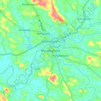
Nom : Carte topographique Muvattupuzha, altitude, relief.
Lieu : Muvattupuzha, Ernakulam, Kerala, 686661, India (9.82315 76.41816 10.14315 76.73816)
Altitude moyenne : 44 m
Altitude minimum : 0 m
Altitude maximum : 603 m
Faire un don
Équipez-vous pour votre prochaine aventure :
En tant que Partenaire Amazon, ce site perçoit une commission sur les achats éligibles sans surcoût pour vous.