
Faire un don
Équipez-vous pour votre prochaine aventure :
En tant que Partenaire Amazon, ce site perçoit une commission sur les achats éligibles sans surcoût pour vous.
Carte topographique Skipton
Cliquez sur la carte pour afficher l’altitude.
Faire un don
Équipez-vous pour votre prochaine aventure :
En tant que Partenaire Amazon, ce site perçoit une commission sur les achats éligibles sans surcoût pour vous.
À propos de cette carte
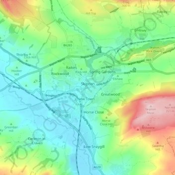
Nom : Carte topographique Skipton, altitude, relief.
Altitude moyenne : 173 m
Altitude minimum : 89 m
Altitude maximum : 367 m
Faire un don
Équipez-vous pour votre prochaine aventure :
En tant que Partenaire Amazon, ce site perçoit une commission sur les achats éligibles sans surcoût pour vous.
Autres cartes topographiques
Cliquez sur une carte pour visualiser sa topographie, son altitude et son relief.
Greenhow Hill
United Kingdom > England > North Yorkshire
The village is about 3 miles (4.8 km) west of Pateley Bridge on the road heading towards Grassington, and is mainly in the civil parish of Bewerley. However, the western end of the village lying to the west of Kell Dyke, commonly known as Craven Cross, lies within the civil parish of Appletreewick in Craven.…
Altitude moyenne : 358 m
Faire un don
Équipez-vous pour votre prochaine aventure :
En tant que Partenaire Amazon, ce site perçoit une commission sur les achats éligibles sans surcoût pour vous.