
Carte topographique Coron
Cliquez sur la carte pour afficher l’altitude.
À propos de cette carte
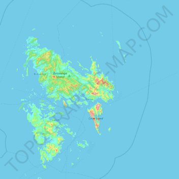
Nom : Carte topographique Coron, altitude, relief.
Lieu : Coron, Palawan, Mimaropa, 5316, Philippines (11.57917 119.95953 12.51583 120.53952)
Altitude moyenne : 13 m
Altitude minimum : -2 m
Altitude maximum : 565 m
Autres cartes topographiques
Cliquez sur une carte pour visualiser sa topographie, son altitude et son relief.
Likas Island
Philippines > Palawan > Kalayaan
West York Island, also known as Likas Island (Filipino: Pulo ng Likas, lit. 'Island of Naturality'; Mandarin Chinese: 西月島/西月岛; pinyin: Xīyuè Dǎo; Vietnamese: đảo Bến Lạc), and several other names. With an area of 18.6 hectares (46 acres), it is the third largest of the naturally…
Altitude moyenne : 0 m