
Carte topographique Colquitt County
Carte interactive
Cliquez sur la carte pour afficher l’altitude.
À propos de cette carte
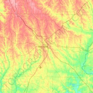
Nom : Carte topographique Colquitt County, altitude, relief.
Lieu : Colquitt County, Georgia, United States (31.02588 -84.01383 31.33502 -83.50542)
Altitude moyenne : 85 m
Altitude minimum : 44 m
Altitude maximum : 134 m
Autres cartes topographiques
Cliquez sur une carte pour visualiser sa topographie, son altitude et son relief.
Chatham County
United States > Georgia > Chatham County
Chatham County, Georgia, United States
Altitude moyenne : 3 m
Toccoa
United States > Georgia > Stephens County
Toccoa, Stephens County, Georgia, 30577, United States
Altitude moyenne : 303 m
Spalding County
Spalding County, Georgia, United States
Altitude moyenne : 247 m
Bonaire
United States > Georgia > Houston County
Bonaire, Houston County, Georgia, 31005, United States
Altitude moyenne : 100 m
Helen
United States > Georgia > White County
Helen, White County, Georgia, 30545, United States
Altitude moyenne : 488 m
Fort Pulaski
United States > Georgia > Chatham County
Fort Pulaski, Fort Perimeter Trail, Chatham County, Georgia, 31328, United States
Altitude moyenne : 1 m
Booth Lake
United States > Georgia > Wilkes County > Washington > Ravenwood Park
Booth Lake, Ravenwood Park, Washington, Wilkes County, Georgia, United States
Altitude moyenne : 175 m
Griffin Lake
United States > Georgia > Brooks County
Griffin Lake, Brooks County, Georgia, United States
Altitude moyenne : 60 m
Rowland Lake
United States > Georgia > Jones County
Rowland Lake, Jones County, Georgia, United States
Altitude moyenne : 175 m
Ponder Park
United States > Georgia > Tift County > Omega
Ponder Park, Omega, Tift County, Georgia, United States
Altitude moyenne : 96 m
Hiawassee
United States > Georgia > Towns County
Hiawassee, Towns County, Georgia, United States
Altitude moyenne : 620 m
Powder Springs
United States > Georgia > Cobb County
Powder Springs, Cobb County, Georgia, United States
Altitude moyenne : 291 m
Brasstown Bald
United States > Georgia > Towns County
Brasstown Bald, Towns County, Georgia, United States
Altitude moyenne : 1.161 m
Adel
United States > Georgia > Cook County
Adel, Cook County, Georgia, 31620, United States
Altitude moyenne : 72 m
Cherokee Hills
United States > Georgia > Coffee County
Cherokee Hills, Coffee County, Georgia, United States
Altitude moyenne : 70 m
Lake City
United States > Georgia > Clayton County
Lake City, Clayton County, Georgia, United States
Altitude moyenne : 287 m
Whitfield County
Whitfield County, Georgia, United States
Altitude moyenne : 258 m
Forbes Lake
United States > Georgia > Macon County
Forbes Lake, Macon County, Georgia, United States
Altitude moyenne : 126 m
Leesburg
United States > Georgia > Lee County
Leesburg, Lee County, Georgia, United States
Altitude moyenne : 76 m
Snodgrass Hill
United States > Georgia > Walker County > Fort Oglethorpe
Snodgrass Hill, Fort Oglethorpe, Walker County, Georgia, 30741, United States
Altitude moyenne : 250 m
Moon River
United States > Georgia > Chatham County > Burnside View
Moon River, Burnside View, Chatham County, Georgia, 31411, United States
Altitude moyenne : 2 m
Rossville
United States > Georgia > Walker County
Rossville, Walker County, Georgia, United States
Altitude moyenne : 251 m
Lake Seminole
United States > Georgia > Seminole County > Chattahoochee
Lake Seminole, Chattahoochee, Seminole County, Georgia, United States
Altitude moyenne : 32 m
Baxley
United States > Georgia > Appling County
Baxley, Appling County, Georgia, 31515, United States
Altitude moyenne : 61 m
Bainbridge
United States > Georgia > Decatur County
Bainbridge, Decatur County, Georgia, United States
Altitude moyenne : 37 m
Shenandoah Woods
United States > Georgia > Columbia County
Shenandoah Woods, Columbia County, Georgia, 30907, United States
Altitude moyenne : 97 m
Hiram
United States > Georgia > Paulding County
Hiram, Paulding County, Georgia, United States
Altitude moyenne : 306 m
Roswell
United States > Georgia > Fulton County
Roswell, Fulton County, Georgia, United States
Altitude moyenne : 316 m
Lawrenceville
United States > Georgia > Gwinnett County
Lawrenceville, Gwinnett County, Georgia, United States
Altitude moyenne : 312 m
High Hill Lake
United States > Georgia > Glynn County
High Hill Lake, Glynn County, Georgia, 31525, United States
Altitude moyenne : 7 m
Newnan
United States > Georgia > Coweta County
Newnan, Coweta County, Georgia, 30263, United States
Altitude moyenne : 272 m
Crowe Lake
United States > Georgia > Gwinnett County
Crowe Lake, Gwinnett County, Georgia, United States
Altitude moyenne : 349 m
Tybee Island
United States > Georgia > Chatham County
Tybee Island, Chatham County, Georgia, 31328, United States
Altitude moyenne : 1 m
Johns Creek
United States > Georgia > Fulton County > Johns Creek
Johns Creek, Fulton County, Georgia, 30097, United States
Altitude moyenne : 305 m
Atlanta
United States > Georgia > Fulton County
Atlanta, Fulton County, Georgia, 30303, United States
Altitude moyenne : 285 m
Peachtree City
United States > Georgia > Fayette County
Peachtree City, Fayette County, Georgia, 30269, United States
Altitude moyenne : 263 m
Milton
United States > Georgia > Fulton County
Milton, Fulton County, Georgia, 30004, United States
Altitude moyenne : 330 m