
Faire un don
Équipez-vous pour votre prochaine aventure :
En tant que Partenaire Amazon, ce site perçoit une commission sur les achats éligibles sans surcoût pour vous.
Carte topographique Borgholm
Cliquez sur la carte pour afficher l’altitude.
Faire un don
Équipez-vous pour votre prochaine aventure :
En tant que Partenaire Amazon, ce site perçoit une commission sur les achats éligibles sans surcoût pour vous.
Borgholm
The name Borgholm is documented to be found from the 1280s. The foreland Borg- is considered to refer to the old ancient castle which is believed to have been located on the site of the castle ruins, but according to another interpretation refers to the eye-catching topography of the site. The significance would then be that berg- is the correct interpretation, and support for this can be found in Gotlandic, where borg can mean beach hill or high sand dune, and that berg-meaning has been well spread throughout the East Nordic area.
Faire un don
Équipez-vous pour votre prochaine aventure :
En tant que Partenaire Amazon, ce site perçoit une commission sur les achats éligibles sans surcoût pour vous.
À propos de cette carte
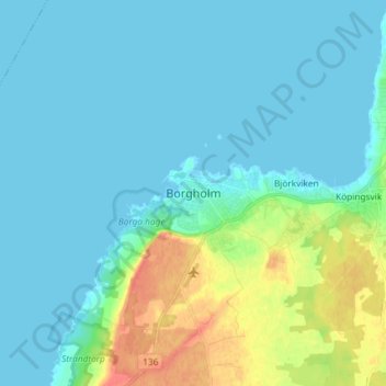
Nom : Carte topographique Borgholm, altitude, relief.
Lieu : Borgholm, Borgholms kommun, Kalmar County, 387 31, Sweden (56.83993 16.61614 56.91993 16.69614)
Altitude moyenne : 10 m
Altitude minimum : -1 m
Altitude maximum : 48 m
Faire un don
Équipez-vous pour votre prochaine aventure :
En tant que Partenaire Amazon, ce site perçoit une commission sur les achats éligibles sans surcoût pour vous.
Autres cartes topographiques
Cliquez sur une carte pour visualiser sa topographie, son altitude et son relief.
Faire un don
Équipez-vous pour votre prochaine aventure :
En tant que Partenaire Amazon, ce site perçoit une commission sur les achats éligibles sans surcoût pour vous.
Faire un don
Équipez-vous pour votre prochaine aventure :
En tant que Partenaire Amazon, ce site perçoit une commission sur les achats éligibles sans surcoût pour vous.