
Carte topographique Wilton
Cliquez sur la carte pour afficher l’altitude.
À propos de cette carte
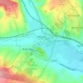
Nom : Carte topographique Wilton, altitude, relief.
Lieu : Wilton, Wiltshire, England, United Kingdom (51.05575 -1.89438 51.10022 -1.84230)
Altitude moyenne : 85 m
Altitude minimum : 45 m
Altitude maximum : 173 m
Autres cartes topographiques
Cliquez sur une carte pour visualiser sa topographie, son altitude et son relief.
Cley Hill
United Kingdom > England > Wiltshire
Cley Hill (grid reference ST838449) is a prominent hill to the west of Warminster in Wiltshire, England. Its summit has a commanding view of the Wiltshire / Somerset county boundary, at 244 metres (801 ft) elevation. The land is in Corsley parish and is owned by the National Trust.
Altitude moyenne : 157 m