
Faire un don
Équipez-vous pour votre prochaine aventure :
En tant que Partenaire Amazon, ce site perçoit une commission sur les achats éligibles sans surcoût pour vous.
Carte topographique Petrolina
Cliquez sur la carte pour afficher l’altitude.
Faire un don
Équipez-vous pour votre prochaine aventure :
En tant que Partenaire Amazon, ce site perçoit une commission sur les achats éligibles sans surcoût pour vous.
Petrolina
Petrolina is situated on the left (northern) bank of the São Francisco River, in the interior semi-arid Sertão subregion, at an elevation of 376 m. On the other side of the river sits Juazeiro, in state of Bahia, and together the cities form an integrated metropolitan area. The two cities, making up an urban area of almost 700,000 people, are connected by the President Dutra Bridge. The Sobradinho Dam is located 26 km up river, and creates the Sobradinho Reservoir, the 34th largest reservoir by volume in the world.
Faire un don
Équipez-vous pour votre prochaine aventure :
En tant que Partenaire Amazon, ce site perçoit une commission sur les achats éligibles sans surcoût pour vous.
À propos de cette carte
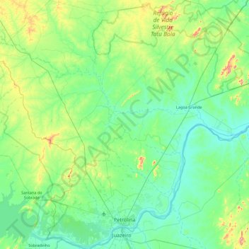
Nom : Carte topographique Petrolina, altitude, relief.
Altitude moyenne : 420 m
Altitude minimum : 349 m
Altitude maximum : 740 m
Faire un don
Équipez-vous pour votre prochaine aventure :
En tant que Partenaire Amazon, ce site perçoit une commission sur les achats éligibles sans surcoût pour vous.
Autres cartes topographiques
Cliquez sur une carte pour visualiser sa topographie, son altitude et son relief.
Boa Paz
Brazil > Pernambuco > Região Administrativa Integrada de Desenvolvimento do Polo Petrolina e Juazeiro > Petrolina
Altitude moyenne : 379 m