
Carte topographique Chammünster
Carte interactive
Cliquez sur la carte pour afficher l’altitude.
À propos de cette carte
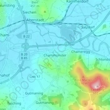
Nom : Carte topographique Chammünster, altitude, relief.
Lieu : Chammünster, Cham, Landkreis Cham, Bayern, 93413, Deutschland (49.19042 12.67515 49.23042 12.71515)
Altitude moyenne : 399 m
Altitude minimum : 366 m
Altitude maximum : 592 m
Autres cartes topographiques
Cliquez sur une carte pour visualiser sa topographie, son altitude et son relief.
Selling
Deutschland > Bayern > Landkreis Cham > Cham > Kothmaißling
Selling, Kothmaißling, Cham, Landkreis Cham, Bayern, 93486, Deutschland
Altitude moyenne : 399 m
Haidhäuser
Deutschland > Bayern > Landkreis Cham > Cham
Haidhäuser, Cham, Landkreis Cham, Bayern, Deutschland
Altitude moyenne : 381 m
Gutmaning
Deutschland > Bayern > Landkreis Cham > Cham
Gutmaning, Cham, Landkreis Cham, Bayern, 93413, Deutschland
Altitude moyenne : 412 m
Laichstätt
Deutschland > Bayern > Landkreis Cham > Cham
Laichstätt, Cham, Landkreis Cham, Bayern, 93482, Deutschland
Altitude moyenne : 374 m