
Faire un don
Équipez-vous pour votre prochaine aventure :
En tant que Partenaire Amazon, ce site perçoit une commission sur les achats éligibles sans surcoût pour vous.
Carte topographique Trident Volcano
Cliquez sur la carte pour afficher l’altitude.
Faire un don
Équipez-vous pour votre prochaine aventure :
En tant que Partenaire Amazon, ce site perçoit une commission sur les achats éligibles sans surcoût pour vous.
Trident Volcano
Trident Volcano is an eroded volcanic complex on the Alaska Peninsula in Katmai National Park, Alaska. Up to 23 domes comprise the complex stratovolcano, with the greatest elevation of 6,115 feet (1,864 m). The most recent major activity produced a 3,599-foot (1,097 m) dome in an amphitheater on the southwest flank of the southwest peak. Volcano Novarupta formed on its slopes in the largest volcanic eruption of the 20th century.
Faire un don
Équipez-vous pour votre prochaine aventure :
En tant que Partenaire Amazon, ce site perçoit une commission sur les achats éligibles sans surcoût pour vous.
À propos de cette carte
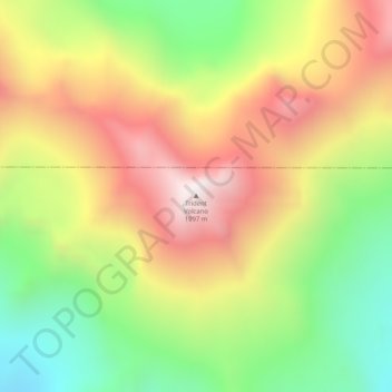
Nom : Carte topographique Trident Volcano, altitude, relief.
Lieu : Trident Volcano, Kodiak Island, Alaska, United States (58.23425 -155.10265 58.23435 -155.10255)
Altitude moyenne : 1.338 m
Altitude minimum : 857 m
Altitude maximum : 1.845 m
Faire un don
Équipez-vous pour votre prochaine aventure :
En tant que Partenaire Amazon, ce site perçoit une commission sur les achats éligibles sans surcoût pour vous.
Autres cartes topographiques
Cliquez sur une carte pour visualiser sa topographie, son altitude et son relief.
Raspberry Island
United States > Alaska > Kodiak Island
Sitka spruce is one of the dominant trees on Raspberry Island. Spruce forests are interrupted by fields of salmonberry bushes, alders and wildflowers. Higher elevations have wild blueberry and cranberry bushes with more grasses. Wildlife of note on the island includes Sitka deer, red foxes and Kodiak bears, as…
Altitude moyenne : 71 m