
Carte topographique Kleiner Seekopf
Carte interactive
Cliquez sur la carte pour afficher l’altitude.
À propos de cette carte
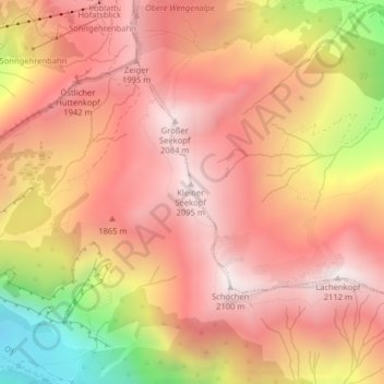
Nom : Carte topographique Kleiner Seekopf, altitude, relief.
Altitude moyenne : 1.711 m
Altitude minimum : 984 m
Altitude maximum : 2.088 m
Autres cartes topographiques
Cliquez sur une carte pour visualiser sa topographie, son altitude et son relief.
Allgäuer Alpen
Deutschland > Bayern > Oberstdorf
Allgäuer Alpen, Bayern, Deutschland
Altitude moyenne : 1.301 m
Nebelhorn
Deutschland > Bayern > Oberstdorf
Nebelhorn, Oberstdorf, Landkreis Oberallgäu, Bayern, Deutschland
Altitude moyenne : 1.792 m
Schwand
Deutschland > Bayern > Oberstdorf > Schwand
Schwand, Oberstdorf, Landkreis Oberallgäu, Bayern, 87561, Deutschland
Altitude moyenne : 1.201 m
Hoher Ifen
Deutschland > Bayern > Oberstdorf
Hoher Ifen, Oberstdorf, Landkreis Oberallgäu, Schwaben, Bayern, Deutschland
Altitude moyenne : 1.826 m
Kleiner Wilder
Deutschland > Bayern > Oberstdorf
Kleiner Wilder, Oberstdorf, Landkreis Oberallgäu, Schwaben, Bayern, Deutschland
Altitude moyenne : 1.839 m
Höfats Ostgipfel
Deutschland > Bayern > Oberstdorf
Höfats Ostgipfel, Oberstdorf, Landkreis Oberallgäu, Schwaben, Bayern, Deutschland
Altitude moyenne : 1.595 m
Bockkarkopf
Deutschland > Bayern > Oberstdorf
Bockkarkopf, Oberstdorf, Landkreis Oberallgäu, Schwaben, Bayern, Deutschland
Altitude moyenne : 2.150 m
Mädelegabel
Deutschland > Bayern > Oberstdorf
Mädelegabel, Oberstdorf, Landkreis Oberallgäu, Schwaben, Bayern, Deutschland
Altitude moyenne : 2.093 m
Rubihorn
Deutschland > Bayern > Oberstdorf
Rubihorn, Oberstdorf, Landkreis Oberallgäu, Schwaben, Bayern, 87561, Deutschland
Altitude moyenne : 1.467 m
Biberkopf
Deutschland > Bayern > Oberstdorf
Biberkopf, Oberstdorf, Landkreis Oberallgäu, Schwaben, Bayern, 6993, Deutschland
Altitude moyenne : 1.956 m
Trettach
Deutschland > Bayern > Oberstdorf
Trettach, Oberstdorf, Landkreis Oberallgäu, Schwaben, Bayern, 87561, Deutschland
Altitude moyenne : 996 m