
Carte topographique Motiong
Cliquez sur la carte pour afficher l’altitude.
À propos de cette carte
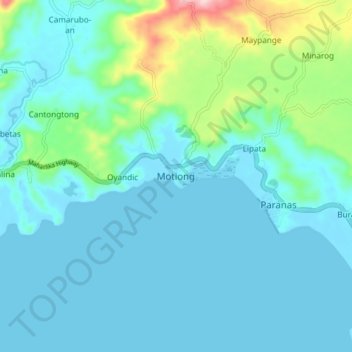
Nom : Carte topographique Motiong, altitude, relief.
Lieu : Motiong, Samar, Eastern Visayas, 6702, Philippines (11.73821 124.95868 11.81821 125.03868)
Altitude moyenne : 39 m
Altitude minimum : -2 m
Altitude maximum : 246 m
Autres cartes topographiques
Cliquez sur une carte pour visualiser sa topographie, son altitude et son relief.
Calbayog
Forty percent of the city's land area are plain and hilly terrains with elevation ranging from 5 to 20 metres (16 to 66 ft) above sea level. The rest are rugged mountain ranges with elevations from 300 to 700 metres (980 to 2,300 ft) above sea level. Flooding is minimized because of many rivers, brooks,…
Altitude moyenne : 78 m
Silanga District of Catbalogan City
Philippines > Samar > Silanga District of Catbalogan City
Altitude moyenne : 21 m
Calbayog
Forty percent of the city's land area are plain and hilly terrains with elevation ranging from 5 to 20 metres (16 to 66 ft) above sea level. The rest are rugged mountain ranges with elevations from 300 to 700 metres (980 to 2,300 ft) above sea level. Flooding is minimized because of many rivers, brooks,…
Altitude moyenne : 78 m