
Carte topographique Glacial Lake
Carte interactive
Cliquez sur la carte pour afficher l’altitude.
À propos de cette carte
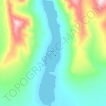
Nom : Carte topographique Glacial Lake, altitude, relief.
Lieu : Glacial Lake, Nome, Alaska, USA (64.83825 -165.71906 64.89184 -165.69263)
Altitude moyenne : 313 m
Altitude minimum : 122 m
Altitude maximum : 867 m
Autres cartes topographiques
Cliquez sur une carte pour visualiser sa topographie, son altitude et son relief.
Mendenhaven
USA > Alaska > Mendenhaven
Mendenhaven, Juneau, Alaska, 99801, USA
Altitude moyenne : 126 m
Kanikula Glacier
Kanikula Glacier, Matanuska-Susitna, Alaska, USA
Altitude moyenne : 1.606 m
Kuskulana Glacier
Kuskulana Glacier, Valdez-Cordova, Alaska, USA
Altitude moyenne : 2.337 m
Worthington Glacier
Worthington Glacier, Richardson Highway, Ptarmigan, Valdez-Cordova, Alaska, USA
Altitude moyenne : 1.356 m
Byron Glacier
Byron Glacier, Byron Glacier Trail, Anchorage, Alaska, USA
Altitude moyenne : 749 m
Explorer Glacier
Explorer Glacier, Trail of Blue Ice, Anchorage, Alaska, USA
Altitude moyenne : 559 m
Exit Glacier
Exit Glacier, Harding Ice Field Approach Trail, Kenai Peninsula, Alaska, USA
Altitude moyenne : 1.092 m
Kuskokwim River
Kuskokwim River, Unorganized Borough, Alaska, USA
Altitude moyenne : 111 m
Cul-de-Sac Glacier
Cul-de-Sac Glacier, Matanuska-Susitna, Alaska, USA
Altitude moyenne : 1.541 m
Revillagigedo Island
Revillagigedo Island, Ketchikan Gateway, Alaska, USA
Altitude moyenne : 342 m
Admiralty Island
Admiralty Island, Hoonah-Angoon, Alaska, 99820, USA
Altitude moyenne : 295 m
Tokositna Glacier
Tokositna Glacier, Matanuska-Susitna, Alaska, USA
Altitude moyenne : 1.485 m
Mount Cleveland
Mount Cleveland, Unorganized Borough, Alaska, USA
Altitude moyenne : 1.022 m