
Carte topographique Lake of the Woods County
Carte interactive
Cliquez sur la carte pour afficher l’altitude.
À propos de cette carte
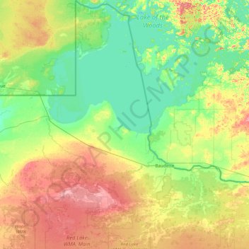
Nom : Carte topographique Lake of the Woods County, altitude, relief.
Lieu : Lake of the Woods County, Minnesota, USA (48.36906 -95.34261 49.38449 -94.43111)
Altitude moyenne : 343 m
Altitude minimum : 317 m
Altitude maximum : 405 m
Autres cartes topographiques
Cliquez sur une carte pour visualiser sa topographie, son altitude et son relief.
Cathedral Hill Park
USA > Minnesota > Saint Paul
Cathedral Hill Park, Saint Paul, Ramsey County, Minnesota, USA
Altitude moyenne : 252 m
Keller Lake
Keller Lake, North Maplewood Drive, Maplewood, Ramsey County, Minnesota, 55109, USA
Altitude moyenne : 272 m
Alexandria
USA > Minnesota > Alexandria
Alexandria, Douglas County, Minnesota, 56308, USA
Altitude moyenne : 426 m
Prospect Park - East River Road
USA > Minnesota > Minneapolis
Prospect Park - East River Road, Minneapolis, Hennepin County, Minnesota, USA
Altitude moyenne : 260 m