
Faire un don
Équipez-vous pour votre prochaine aventure :
En tant que Partenaire Amazon, ce site perçoit une commission sur les achats éligibles sans surcoût pour vous.
Carte topographique Vadodara
Cliquez sur la carte pour afficher l’altitude.
Faire un don
Équipez-vous pour votre prochaine aventure :
En tant que Partenaire Amazon, ce site perçoit une commission sur les achats éligibles sans surcoût pour vous.
Vadodara
Vadodara is located at 22°18′N 73°11′E / 22.30°N 73.19°E / 22.30; 73.19 in western India at an elevation of 128 ft (39 m). It is the 10th-largest city in India with an area of 400 km2 (150 sq mi) and a population of 3.5 million, according to the 2010–11 census. The city sits on the banks of the Vishwamitri River, in central Gujarat. The Vishwamitri frequently dries up in the summer, leaving only a small stream of water. The city is located on the fertile plain between the Mahi and Narmada Rivers. According to the Bureau of Indian Standards, the cosmopolis falls under seismic zone-III, on a scale of I to V (in order of increasing proneness to earthquakes).
Faire un don
Équipez-vous pour votre prochaine aventure :
En tant que Partenaire Amazon, ce site perçoit une commission sur les achats éligibles sans surcoût pour vous.
À propos de cette carte
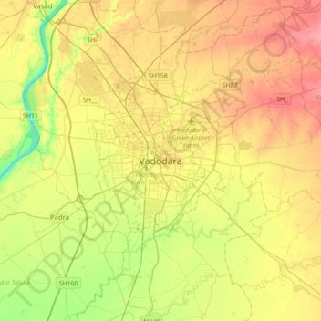
Nom : Carte topographique Vadodara, altitude, relief.
Altitude moyenne : 36 m
Altitude minimum : 0 m
Altitude maximum : 71 m
Faire un don
Équipez-vous pour votre prochaine aventure :
En tant que Partenaire Amazon, ce site perçoit une commission sur les achats éligibles sans surcoût pour vous.
Autres cartes topographiques
Cliquez sur une carte pour visualiser sa topographie, son altitude et son relief.