
Faire un don
Équipez-vous pour votre prochaine aventure :
En tant que Partenaire Amazon, ce site perçoit une commission sur les achats éligibles sans surcoût pour vous.
Carte topographique Mangaung Metropolitan Municipality
Cliquez sur la carte pour afficher l’altitude.
Faire un don
Équipez-vous pour votre prochaine aventure :
En tant que Partenaire Amazon, ce site perçoit une commission sur les achats éligibles sans surcoût pour vous.
À propos de cette carte
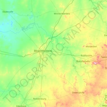
Nom : Carte topographique Mangaung Metropolitan Municipality, altitude, relief.
Lieu : Mangaung Metropolitan Municipality, Free State, South Africa (-29.53391 25.71936 -28.76006 27.09448)
Altitude moyenne : 1.401 m
Altitude minimum : 1.210 m
Altitude maximum : 2.094 m
Faire un don
Équipez-vous pour votre prochaine aventure :
En tant que Partenaire Amazon, ce site perçoit une commission sur les achats éligibles sans surcoût pour vous.
Autres cartes topographiques
Cliquez sur une carte pour visualiser sa topographie, son altitude et son relief.
Phuthaditjhaba
South Africa > Free State > Thabo Mofutsanyana District Municipality > Maluti-a-Phofung Local Municipality
Altitude moyenne : 1.736 m
Bethlehem
South Africa > Free State > Thabo Mofutsanyana District Municipality > Dihlabeng Local Municipality
The city lies at an altitude of 1,700 metres (5,600 ft) and this contributes to its cool climate with frosty winters and mild summers. The average annual temperature is around 14 °C (57 °F).
Altitude moyenne : 1.675 m
Bloemfontein
South Africa > Free State > Mangaung Metropolitan Municipality
Situated at an elevation of 1,395 m (4,577 ft) above sea level, the city is home to approximately 520,000 residents and forms part of the Mangaung Metropolitan Municipality which has a population of 747,431. It was one of the host cities for the 2010 FIFA World Cup.
Altitude moyenne : 1.374 m
Vrede
South Africa > Free State > Thabo Mofutsanyana District Municipality > Phumelela Local Municipality
Altitude moyenne : 1.678 m
Faire un don
Équipez-vous pour votre prochaine aventure :
En tant que Partenaire Amazon, ce site perçoit une commission sur les achats éligibles sans surcoût pour vous.
Sasolburg
South Africa > Free State > Fezile Dabi District Municipality > Metsimaholo Local Municipality
Sasolburg is at a high altitude with a fairly dry climate and large seasonal temperature variation. It is situated on the banks of the Vaal River, which separates the Free State from the former Transvaal Province, and is not far from the Vaal Dam where excellent windsurfing spots can be found.
Altitude moyenne : 1.469 m
Kroonstad
South Africa > Free State > Fezile Dabi District Municipality > Moqhaka Local Municipality
Altitude moyenne : 1.380 m
Clarens
South Africa > Free State > Thabo Mofutsanyana District Municipality > Dihlabeng Local Municipality
Altitude moyenne : 1.874 m
Faire un don
Équipez-vous pour votre prochaine aventure :
En tant que Partenaire Amazon, ce site perçoit une commission sur les achats éligibles sans surcoût pour vous.
Viljoenskroon
South Africa > Free State > Fezile Dabi District Municipality > Moqhaka Local Municipality
Altitude moyenne : 1.335 m
Vaal Dam
South Africa > Free State > Fezile Dabi District Municipality > Metsimaholo Local Municipality > Deneysville
Altitude moyenne : 1.481 m
Fouriesburg
South Africa > Free State > Thabo Mofutsanyana District Municipality > Dihlabeng Local Municipality
Altitude moyenne : 1.745 m
Bothaville
South Africa > Free State > Lejweleputswa District Municipality > Nala Local Municipality
Altitude moyenne : 1.287 m
Faire un don
Équipez-vous pour votre prochaine aventure :
En tant que Partenaire Amazon, ce site perçoit une commission sur les achats éligibles sans surcoût pour vous.
Parys
South Africa > Free State > Fezile Dabi District Municipality > Ngwathe Local Municipality
Altitude moyenne : 1.408 m
Ficksburg
South Africa > Free State > Thabo Mofutsanyana District Municipality > Setsoto Local Municipality
Altitude moyenne : 1.617 m
Welkom
South Africa > Free State > Lejweleputswa District Municipality
Koppie Alleen is the only hill near Welkom and therefore is aptly named for its oddity. The terrain elevation above sea level is 1435 metres. The largest water catchment is the Sand River to the south-east of Welkom in Virginia's direction. Large saline pans such as Flamingo Pan and Theronia Pan are situated…
Altitude moyenne : 1.341 m
Faire un don
Équipez-vous pour votre prochaine aventure :
En tant que Partenaire Amazon, ce site perçoit une commission sur les achats éligibles sans surcoût pour vous.
Koppies Dam
South Africa > Free State > Fezile Dabi District Municipality > Ngwathe Local Municipality
Altitude moyenne : 1.399 m
Zastron
South Africa > Free State > Xhariep District Municipality > Mohokare Local Municipality
Altitude moyenne : 1.719 m
Hoopstad
South Africa > Free State > Lejweleputswa District Municipality > Tswelopele Local Municipality
Altitude moyenne : 1.251 m
Mont Pelaan
South Africa > Free State > Thabo Mofutsanyana District Municipality > Phumelela Local Municipality
Altitude moyenne : 1.960 m
Faire un don
Équipez-vous pour votre prochaine aventure :
En tant que Partenaire Amazon, ce site perçoit une commission sur les achats éligibles sans surcoût pour vous.
Hlohlolwane (Clocolan)
South Africa > Free State > Thabo Mofutsanyana District Municipality > Setsoto Local Municipality
Altitude moyenne : 1.593 m
Bultfontein
South Africa > Free State > Lejweleputswa District Municipality > Tswelopele Local Municipality
Altitude moyenne : 1.326 m
Harmony
South Africa > Free State > Lejweleputswa District Municipality > Matjhabeng Local Municipality
Altitude moyenne : 1.333 m
Deneysville
South Africa > Free State > Fezile Dabi District Municipality > Metsimaholo Local Municipality
Altitude moyenne : 1.496 m
Faire un don
Équipez-vous pour votre prochaine aventure :
En tant que Partenaire Amazon, ce site perçoit une commission sur les achats éligibles sans surcoût pour vous.
Winnie Mandela (Brandfort)
South Africa > Free State > Lejweleputswa District Municipality > Masilonyana Local Municipality
Altitude moyenne : 1.403 m
Virginia
South Africa > Free State > Lejweleputswa District Municipality > Matjhabeng Local Municipality
Altitude moyenne : 1.326 m
Ladybrand
South Africa > Free State > Thabo Mofutsanyana District Municipality > Mantsopa Local Municipality
Altitude moyenne : 1.634 m
Reddersburg
South Africa > Free State > Xhariep District Municipality > Kopanong Local Municipality
Altitude moyenne : 1.423 m
Faire un don
Équipez-vous pour votre prochaine aventure :
En tant que Partenaire Amazon, ce site perçoit une commission sur les achats éligibles sans surcoût pour vous.
Renoster River
South Africa > Free State > Thabo Mofutsanyana District Municipality > Nketoana Local Municipality
Altitude moyenne : 1.587 m
Theunissen
South Africa > Free State > Lejweleputswa District Municipality > Masilonyana Local Municipality
Altitude moyenne : 1.395 m
Odendaalsrus
South Africa > Free State > Lejweleputswa District Municipality > Matjhabeng Local Municipality
Altitude moyenne : 1.336 m
Reitz
South Africa > Free State > Thabo Mofutsanyana District Municipality > Nketoana Local Municipality
Reitz is located in the north-eastern part of the Free State province, 300 kilometres (190 mi) north-east of Bloemfontein and 180 kilometres (110 mi) south of Johannesburg. It lies roughly halfway between the towns of Bethlehem and Frankfort, at an elevation of 1,630 metres (5,350 ft).
Altitude moyenne : 1.648 m
Faire un don
Équipez-vous pour votre prochaine aventure :
En tant que Partenaire Amazon, ce site perçoit une commission sur les achats éligibles sans surcoût pour vous.
Hertzogville
South Africa > Free State > Lejweleputswa District Municipality > Tokologo Local Municipality
Altitude moyenne : 1.285 m
Wesselsbron
South Africa > Free State > Lejweleputswa District Municipality > Nala Local Municipality
Altitude moyenne : 1.297 m
Verkeerdevlei
South Africa > Free State > Lejweleputswa District Municipality > Masilonyana Local Municipality
Altitude moyenne : 1.474 m
Rouxville
South Africa > Free State > Xhariep District Municipality > Mohokare Local Municipality
Altitude moyenne : 1.518 m
Faire un don
Équipez-vous pour votre prochaine aventure :
En tant que Partenaire Amazon, ce site perçoit une commission sur les achats éligibles sans surcoût pour vous.
Swartkrans
South Africa > Free State > Thabo Mofutsanyana District Municipality > Dihlabeng Local Municipality
Altitude moyenne : 2.036 m
Marquard
South Africa > Free State > Thabo Mofutsanyana District Municipality > Setsoto Local Municipality
Altitude moyenne : 1.512 m
Bloemhof Dam
South Africa > Free State > Lejweleputswa District Municipality > Tswelopele Local Municipality
Altitude moyenne : 1.228 m
Wilge River
South Africa > Free State > Thabo Mofutsanyana District Municipality > Maluti-a-Phofung Local Municipality
Altitude moyenne : 1.739 m
Faire un don
Équipez-vous pour votre prochaine aventure :
En tant que Partenaire Amazon, ce site perçoit une commission sur les achats éligibles sans surcoût pour vous.
Koeberg
South Africa > Free State > Thabo Mofutsanyana District Municipality > Dihlabeng Local Municipality
Altitude moyenne : 2.167 m
Mabula
South Africa > Free State > Thabo Mofutsanyana District Municipality > Mantsopa Local Municipality
Altitude moyenne : 1.766 m
Smithfield
South Africa > Free State > Xhariep District Municipality > Mohokare Local Municipality
Altitude moyenne : 1.441 m
Faire un don
Équipez-vous pour votre prochaine aventure :
En tant que Partenaire Amazon, ce site perçoit une commission sur les achats éligibles sans surcoût pour vous.
Tierpoort
South Africa > Free State > Xhariep District Municipality > Kopanong Local Municipality
Altitude moyenne : 1.301 m
Mount Morkel
South Africa > Free State > Thabo Mofutsanyana District Municipality > Dihlabeng Local Municipality
Altitude moyenne : 1.849 m
HJ Joel Nature Reserve
South Africa > Free State > Lejweleputswa District Municipality > Masilonyana Local Municipality
Altitude moyenne : 1.386 m
Fauresmith
South Africa > Free State > Xhariep District Municipality > Kopanong Local Municipality
Altitude moyenne : 1.411 m
Faire un don
Équipez-vous pour votre prochaine aventure :
En tant que Partenaire Amazon, ce site perçoit une commission sur les achats éligibles sans surcoût pour vous.
Edenville
South Africa > Free State > Fezile Dabi District Municipality > Ngwathe Local Municipality
Altitude moyenne : 1.514 m
Erfenis Dam
South Africa > Free State > Lejweleputswa District Municipality > Masilonyana Local Municipality
Altitude moyenne : 1.356 m
Bohlokong
South Africa > Free State > Thabo Mofutsanyana District Municipality > Dihlabeng Local Municipality
Altitude moyenne : 1.633 m
Van Stadensrus
South Africa > Free State > Xhariep District Municipality > Naledi Local Municipality
Altitude moyenne : 1.479 m
Faire un don
Équipez-vous pour votre prochaine aventure :
En tant que Partenaire Amazon, ce site perçoit une commission sur les achats éligibles sans surcoût pour vous.
Heilbron
South Africa > Free State > Fezile Dabi District Municipality > Ngwathe Local Municipality
Altitude moyenne : 1.559 m
Elands River
South Africa > Free State > Thabo Mofutsanyana District Municipality > Maluti-a-Phofung Local Municipality
Altitude moyenne : 1.638 m
Rustfontein Dam
South Africa > Free State > Mangaung Metropolitan Municipality
Altitude moyenne : 1.375 m
Driekloof Dam
South Africa > Free State > Thabo Mofutsanyana District Municipality > Maluti-a-Phofung Local Municipality
Altitude moyenne : 1.743 m
Faire un don
Équipez-vous pour votre prochaine aventure :
En tant que Partenaire Amazon, ce site perçoit une commission sur les achats éligibles sans surcoût pour vous.
Lindley
South Africa > Free State > Thabo Mofutsanyana District Municipality > Nketoana Local Municipality
Altitude moyenne : 1.540 m
Welkom
South Africa > Free State > Lejweleputswa District Municipality
Koppie Alleen is the only hill near Welkom and therefore is aptly named for its oddity. The terrain elevation above sea level is 1435 metres. The largest water catchment is the Sand River to the south-east of Welkom in Virginia's direction. Large saline pans such as Flamingo Pan and Theronia Pan are situated…
Altitude moyenne : 1.341 m
Bethlehem
South Africa > Free State > Thabo Mofutsanyana District Municipality > Dihlabeng Local Municipality
The city lies at an altitude of 1,700 metres (5,600 ft), which contributes to its cool climate, with frosty winters and mild summers. The average annual temperature is around 14 °C (57 °F).
Altitude moyenne : 1.675 m
Bothaville
South Africa > Free State > Lejweleputswa District Municipality > Nala Local Municipality
Altitude moyenne : 1.287 m
Faire un don
Équipez-vous pour votre prochaine aventure :
En tant que Partenaire Amazon, ce site perçoit une commission sur les achats éligibles sans surcoût pour vous.
Heilbron
South Africa > Free State > Fezile Dabi District Municipality > Ngwathe Local Municipality
Altitude moyenne : 1.559 m
Kroonstad
South Africa > Free State > Fezile Dabi District Municipality > Moqhaka Local Municipality
Altitude moyenne : 1.380 m
Heilbron
South Africa > Free State > Fezile Dabi District Municipality > Ngwathe Local Municipality
Altitude moyenne : 1.559 m
Parys
South Africa > Free State > Fezile Dabi District Municipality > Ngwathe Local Municipality
Altitude moyenne : 1.408 m
Faire un don
Équipez-vous pour votre prochaine aventure :
En tant que Partenaire Amazon, ce site perçoit une commission sur les achats éligibles sans surcoût pour vous.
Sterkfontein Dam
South Africa > Free State > Thabo Mofutsanyana District Municipality > Maluti-a-Phofung Local Municipality
Altitude moyenne : 1.677 m
Ficksburg
South Africa > Free State > Thabo Mofutsanyana District Municipality > Setsoto Local Municipality
Altitude moyenne : 1.617 m
Renoster River
South Africa > Free State > Thabo Mofutsanyana District Municipality > Nketoana Local Municipality > Petrus Steyn
Altitude moyenne : 1.698 m
Bronville
South Africa > Free State > Lejweleputswa District Municipality > Matjhabeng Local Municipality
Altitude moyenne : 1.365 m
Faire un don
Équipez-vous pour votre prochaine aventure :
En tant que Partenaire Amazon, ce site perçoit une commission sur les achats éligibles sans surcoût pour vous.
Vaal Dam
South Africa > Free State > Fezile Dabi District Municipality > Metsimaholo Local Municipality > Deneysville
Altitude moyenne : 1.481 m
Sasolburg
South Africa > Free State > Fezile Dabi District Municipality > Metsimaholo Local Municipality
Sasolburg is at a high altitude with a fairly dry climate and large seasonal temperature variation. It is situated on the banks of the Vaal River, which separates the Free State from the former Transvaal Province, and is not far from the Vaal Dam where excellent windsurfing spots can be found.
Altitude moyenne : 1.469 m
Welkom
South Africa > Free State > Lejweleputswa District Municipality
Koppie Alleen is the only hill near Welkom and therefore is aptly named for its oddity. The terrain elevation above sea level is 1435 metres. The largest water catchment is the Sand River to the south-east of Welkom in Virginia's direction. Large saline pans such as Flamingo Pan and Theronia Pan are situated…
Altitude moyenne : 1.341 m
Vaal Dam
South Africa > Free State > Fezile Dabi District Municipality > Metsimaholo Local Municipality > Deneysville
Altitude moyenne : 1.481 m
Faire un don
Équipez-vous pour votre prochaine aventure :
En tant que Partenaire Amazon, ce site perçoit une commission sur les achats éligibles sans surcoût pour vous.
Welkom
South Africa > Free State > Lejweleputswa District Municipality
Koppie Alleen is the only hill near Welkom and therefore is aptly named for its oddity. The terrain elevation above sea level is 1435 metres. The largest water catchment is the Sand River to the south-east of Welkom in Virginia's direction. Large saline pans such as Flamingo Pan and Theronia Pan are situated…
Altitude moyenne : 1.341 m
Bothaville
South Africa > Free State > Lejweleputswa District Municipality > Nala Local Municipality
Altitude moyenne : 1.287 m
Jacobsdal
South Africa > Free State > Xhariep District Municipality > Letsemeng Local Municipality
Altitude moyenne : 1.147 m
Bloemfontein
South Africa > Free State > Mangaung Metropolitan Municipality
Situated at an elevation of 1,395 m (4,577 ft) above sea level, the city is home to 256,185 (as of 2011) residents and forms part of the Mangaung Metropolitan Municipality which has a population of 747,431. It was one of the host cities for the 2010 FIFA World Cup.
Altitude moyenne : 1.374 m
Faire un don
Équipez-vous pour votre prochaine aventure :
En tant que Partenaire Amazon, ce site perçoit une commission sur les achats éligibles sans surcoût pour vous.
Vredefort
South Africa > Free State > Fezile Dabi District Municipality > Ngwathe Local Municipality
Altitude moyenne : 1.430 m
Bloemfontein
South Africa > Free State > Mangaung Metropolitan Municipality
Situated at an elevation of 1,395 m (4,577 ft) above sea level, the city is home to 256,185 (as of 2011) residents and forms part of the Mangaung Metropolitan Municipality which has a population of 747,431. It was one of the host cities for the 2010 FIFA World Cup.
Altitude moyenne : 1.374 m
Paul Roux
South Africa > Free State > Thabo Mofutsanyana District Municipality > Dihlabeng Local Municipality
Altitude moyenne : 1.580 m
Faire un don
Équipez-vous pour votre prochaine aventure :
En tant que Partenaire Amazon, ce site perçoit une commission sur les achats éligibles sans surcoût pour vous.
Rainfall Dam
South Africa > Free State > Thabo Mofutsanyana District Municipality > Maluti-a-Phofung Local Municipality
Altitude moyenne : 1.707 m
iNtabazwe (Harrismith)
South Africa > Free State > Thabo Mofutsanyana District Municipality > Maluti-a-Phofung Local Municipality
Altitude moyenne : 1.716 m
Petrus Steyn
South Africa > Free State > Thabo Mofutsanyana District Municipality > Nketoana Local Municipality
Altitude moyenne : 1.688 m
Highveld
South Africa > Free State > Lejweleputswa District Municipality > Matjhabeng Local Municipality
The Highveld (Afrikaans: Hoëveld, pronounced [ˈɦuəfælt], lit. 'High Field') is the portion of the South African inland plateau which has an altitude above roughly 1,500 m (4,900 ft), but below 2,100 m (6,900 ft), thus excluding the Lesotho mountain regions to the south-east of the Highveld. It is home…
Altitude moyenne : 1.380 m
Faire un don
Équipez-vous pour votre prochaine aventure :
En tant que Partenaire Amazon, ce site perçoit une commission sur les achats éligibles sans surcoût pour vous.
Bloemfontein
South Africa > Free State > Mangaung Metropolitan Municipality
Situated at an elevation of 1,395 m (4,577 ft) above sea level, the city is home to 256,185 (as of 2011) residents and forms part of the Mangaung Metropolitan Municipality which has a population of 747,431. It was one of the host cities for the 2010 FIFA World Cup.
Altitude moyenne : 1.374 m
Senekal
South Africa > Free State > Thabo Mofutsanyana District Municipality > Setsoto Local Municipality
Altitude moyenne : 1.451 m
Odendaalsrus
South Africa > Free State > Lejweleputswa District Municipality > Matjhabeng Local Municipality
Altitude moyenne : 1.336 m
Faire un don
Équipez-vous pour votre prochaine aventure :
En tant que Partenaire Amazon, ce site perçoit une commission sur les achats éligibles sans surcoût pour vous.
Bloemfontein
South Africa > Free State > Mangaung Metropolitan Municipality
Situated at an elevation of 1,395 m (4,577 ft) above sea level, the city is home to 256,185 (as of 2011) residents and forms part of the Mangaung Metropolitan Municipality which has a population of 747,431. It was one of the host cities for the 2010 FIFA World Cup.
Altitude moyenne : 1.374 m
Viljoenskroon
South Africa > Free State > Fezile Dabi District Municipality > Moqhaka Local Municipality
Altitude moyenne : 1.335 m
Paardeberg
South Africa > Free State > Xhariep District Municipality > Letsemeng Local Municipality
Altitude moyenne : 1.168 m
Faire un don
Équipez-vous pour votre prochaine aventure :
En tant que Partenaire Amazon, ce site perçoit une commission sur les achats éligibles sans surcoût pour vous.
Bloemspruit
South Africa > Free State > Mangaung Metropolitan Municipality > Bloemfontein
Altitude moyenne : 1.376 m
Bethlehem
South Africa > Free State > Thabo Mofutsanyana District Municipality > Dihlabeng Local Municipality
The city lies at an altitude of 1,700 metres (5,600 ft) and this contributes to its cool climate with frosty winters and mild summers. The average annual temperature is around 14 °C (57 °F).
Altitude moyenne : 1.675 m
Dewetsdorp
South Africa > Free State > Xhariep District Municipality > Naledi Local Municipality
Altitude moyenne : 1.566 m
Bloemfontein
South Africa > Free State > Mangaung Metropolitan Municipality
Situated at an elevation of 1,395 m (4,577 ft) above sea level, the city is home to 256,185 (as of 2011) residents and forms part of the Mangaung Metropolitan Municipality which has a population of 747,431. It was one of the host cities for the 2010 FIFA World Cup.
Altitude moyenne : 1.374 m
Faire un don
Équipez-vous pour votre prochaine aventure :
En tant que Partenaire Amazon, ce site perçoit une commission sur les achats éligibles sans surcoût pour vous.
Mabula
South Africa > Free State > Thabo Mofutsanyana District Municipality > Mantsopa Local Municipality
Altitude moyenne : 1.766 m
Gariep Dam
South Africa > Free State > Xhariep District Municipality > Kopanong Local Municipality
Altitude moyenne : 1.266 m
Allanridge
South Africa > Free State > Lejweleputswa District Municipality > Matjhabeng Local Municipality
Altitude moyenne : 1.311 m
Marquard
South Africa > Free State > Thabo Mofutsanyana District Municipality > Setsoto Local Municipality
Altitude moyenne : 1.512 m
Faire un don
Équipez-vous pour votre prochaine aventure :
En tant que Partenaire Amazon, ce site perçoit une commission sur les achats éligibles sans surcoût pour vous.