
Carte topographique Tagaytay
Carte interactive
Cliquez sur la carte pour afficher l’altitude.
À propos de cette carte
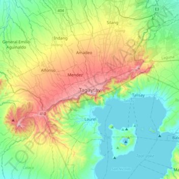
Nom : Carte topographique Tagaytay, altitude, relief.
Lieu : Tagaytay, Cavite, Calabarzon, 4120, Philippines (13.94333 120.77209 14.26333 121.09209)
Altitude moyenne : 229 m
Altitude minimum : -3 m
Altitude maximum : 762 m
The southern and eastern portions of Tagaytay are covered by hills and mountains which is generally forests, pine trees and open grasslands. The city lies along Tagaytay Ridge, a ridge stretching about 32 kilometres (20 mi) from Mount Batulao in the west to Mount Sungay in the east with elevations averaging about 610 metres (2,000 ft) above sea level. Mount Sungay, in Tagaytay, is the highest point of the province of Cavite at 709 metres (2,326 ft).