
Faire un don
Équipez-vous pour votre prochaine aventure :
En tant que Partenaire Amazon, ce site perçoit une commission sur les achats éligibles sans surcoût pour vous.
Carte topographique Diamond Peak
Cliquez sur la carte pour afficher l’altitude.
Faire un don
Équipez-vous pour votre prochaine aventure :
En tant que Partenaire Amazon, ce site perçoit une commission sur les achats éligibles sans surcoût pour vous.
À propos de cette carte
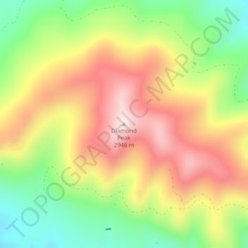
Nom : Carte topographique Diamond Peak, altitude, relief.
Lieu : Diamond Peak, Moffat County, Colorado, United States (40.95019 -108.87822 40.95029 -108.87812)
Altitude moyenne : 2.727 m
Altitude minimum : 2.519 m
Altitude maximum : 2.932 m
Faire un don
Équipez-vous pour votre prochaine aventure :
En tant que Partenaire Amazon, ce site perçoit une commission sur les achats éligibles sans surcoût pour vous.
Autres cartes topographiques
Cliquez sur une carte pour visualiser sa topographie, son altitude et son relief.
Dinosaur National Monument
United States > Colorado > Moffat County
Originally preserved in 1915 to protect its famous Dinosaur Quarry, the monument was greatly expanded in 1938 to include its wealth of natural history. The park's wild landscapes, topography, geology, paleontology, and history make it a unique resource for both science and recreation. The park contains over…
Altitude moyenne : 1.988 m
Faire un don
Équipez-vous pour votre prochaine aventure :
En tant que Partenaire Amazon, ce site perçoit une commission sur les achats éligibles sans surcoût pour vous.