
Carte topographique Osceola Oaks
Carte interactive
Cliquez sur la carte pour afficher l’altitude.
À propos de cette carte
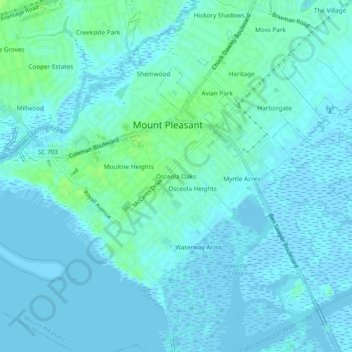
Nom : Carte topographique Osceola Oaks, altitude, relief.
Altitude moyenne : 3 m
Altitude minimum : -3 m
Altitude maximum : 11 m
Autres cartes topographiques
Cliquez sur une carte pour visualiser sa topographie, son altitude et son relief.
Wando Estates
United States > South Carolina > Charleston County > Mount Pleasant
Wando Estates, Mount Pleasant, Charleston County, South Carolina, 29464, United States
Altitude moyenne : 5 m
Brook Green Meadow
United States > South Carolina > Charleston County > Mount Pleasant
Brook Green Meadow, Mount Pleasant, Charleston County, South Carolina, 29964, United States
Altitude moyenne : 4 m
Millwood
United States > South Carolina > Charleston County > Mount Pleasant
Millwood, Mount Pleasant, Charleston County, South Carolina, 29964, United States
Altitude moyenne : 4 m
Waterway Arms
United States > South Carolina > Charleston County > Mount Pleasant
Waterway Arms, Mount Pleasant, Charleston County, South Carolina, 29964, United States
Altitude moyenne : 2 m
Osceola Heights
United States > South Carolina > Charleston County > Mount Pleasant
Osceola Heights, Mount Pleasant, Charleston County, South Carolina, 29964, United States
Altitude moyenne : 3 m
Hickory Shadows
United States > South Carolina > Charleston County > Mount Pleasant
Hickory Shadows, Mount Pleasant, Charleston County, South Carolina, 29464, United States
Altitude moyenne : 4 m
Palmetto Fort
United States > South Carolina > Charleston County > Mount Pleasant
Palmetto Fort, Mount Pleasant, Charleston County, South Carolina, 29466, United States
Altitude moyenne : 4 m