
Carte topographique Davenport
Carte interactive
Cliquez sur la carte pour afficher l’altitude.
À propos de cette carte
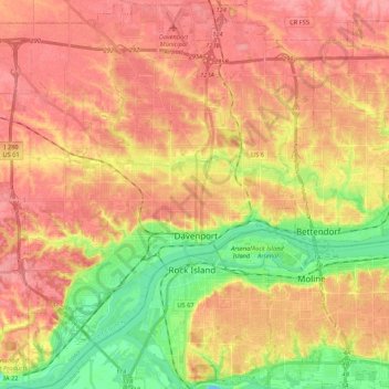
Nom : Carte topographique Davenport, altitude, relief.
Lieu : Davenport, Scott County, Iowa, United States (41.46063 -90.68793 41.62029 -90.49082)
Altitude moyenne : 205 m
Altitude minimum : 157 m
Altitude maximum : 237 m
Autres cartes topographiques
Cliquez sur une carte pour visualiser sa topographie, son altitude et son relief.
Park View
United States > Iowa > Scott County
Park View, Scott County, Iowa, United States
Altitude moyenne : 235 m
Buffalo
United States > Iowa > Scott County
Buffalo, Buffalo Township, Scott County, Iowa, 52728, United States
Altitude moyenne : 205 m
Sheridan Township
United States > Iowa > Scott County
Sheridan Township, Scott County, Iowa, 52748, United States
Altitude moyenne : 231 m
Bettendorf
United States > Iowa > Scott County > Pleasant Valley Township
Bettendorf, Pleasant Valley Township, Scott County, Iowa, 52722, United States
Altitude moyenne : 207 m
Pleasant Valley Township
United States > Iowa > Scott County
Pleasant Valley Township, Scott County, Iowa, United States
Altitude moyenne : 198 m
Le Claire
United States > Iowa > Scott County
Le Claire, Le Claire Township, Scott County, Iowa, United States
Altitude moyenne : 200 m
Walcott
United States > Iowa > Scott County > Walcott
Walcott, Blue Grass Township, Scott County, Iowa, United States
Altitude moyenne : 227 m
Eldridge
United States > Iowa > Scott County
Eldridge, Sheridan Township, Scott County, Iowa, 52748, United States
Altitude moyenne : 234 m
Davenport
United States > Iowa > Scott County > Davenport
Davenport, Scott County, Iowa, 52801, United States
Altitude moyenne : 212 m
Blue Grass
United States > Iowa > Scott County
Blue Grass, Blue Grass Township, Scott County, Iowa, United States
Altitude moyenne : 239 m
Long Grove
United States > Iowa > Scott County
Long Grove, Scott County, Iowa, United States
Altitude moyenne : 235 m