
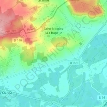
Carte topographique Saint-Nicolas-la-Chapelle
Carte interactive
Cliquez sur la carte pour afficher l’altitude.
À propos de cette carte
Nom : Carte topographique Saint-Nicolas-la-Chapelle, altitude, relief.
Altitude moyenne : 91 m
Altitude minimum : 51 m
Altitude maximum : 188 m
Autres cartes topographiques
Cliquez sur une carte pour visualiser sa topographie, son altitude et son relief.
Rue du Moulin
France > Grand Est > Aube > Argançon
Rue du Moulin, Argançon, Bar-sur-Aube, Aube, Grand Est, France métropolitaine, 10140, France
Altitude moyenne : 215 m
Voie des Brebis
France > Grand Est > Aube > Cussangy
Voie des Brebis, Cussangy, Troyes, Aube, Grand Est, France métropolitaine, 10210, France
Altitude moyenne : 187 m
Rigny-le-Ferron
Rigny-le-Ferron, Troyes, Aube, Grand Est, France métropolitaine, 10160, France
Altitude moyenne : 168 m
Arrentières
Arrentières, Bar-sur-Aube, Aube, Grand Est, France métropolitaine, 10200, France
Altitude moyenne : 268 m
Le Village
France > Grand Est > Aube > Fouchères
Le Village, Fouchères, Troyes, Aube, Grand Est, France métropolitaine, 10260, France
Altitude moyenne : 151 m
Mesnil-Saint-Père
Mesnil-Saint-Père, Troyes, Aube, Grand Est, France métropolitaine, 10140, France
Altitude moyenne : 140 m
Lusigny-sur-Barse
Lusigny-sur-Barse, Troyes, Aube, Grand Est, France métropolitaine, 10270, France
Altitude moyenne : 128 m
Landreville
France > Grand Est > Aube > Landreville > Landreville
Landreville, Troyes, Aube, Grand Est, France métropolitaine, 10110, France
Altitude moyenne : 219 m
Nogent-sur-Seine
Nogent-sur-Seine, Aube, Grand Est, France métropolitaine, 10400, France
Altitude moyenne : 73 m
Landreville
Landreville, Troyes, Aube, Grand Est, France métropolitaine, 10110, France
Altitude moyenne : 232 m
Mailly-le-Camp
Mailly-le-Camp, Troyes, Aube, Grand Est, France métropolitaine, 10230, France
Altitude moyenne : 153 m