
Faire un don
Équipez-vous pour votre prochaine aventure :
En tant que Partenaire Amazon, ce site perçoit une commission sur les achats éligibles sans surcoût pour vous.
Carte topographique Maldon
Cliquez sur la carte pour afficher l’altitude.
Faire un don
Équipez-vous pour votre prochaine aventure :
En tant que Partenaire Amazon, ce site perçoit une commission sur les achats éligibles sans surcoût pour vous.
À propos de cette carte
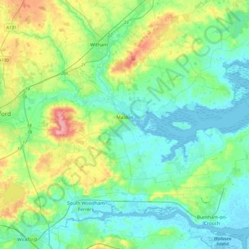
Nom : Carte topographique Maldon, altitude, relief.
Lieu : Maldon, Essex, England, United Kingdom (51.61844 0.58910 51.82912 0.98207)
Altitude moyenne : 27 m
Altitude minimum : -4 m
Altitude maximum : 113 m
Faire un don
Équipez-vous pour votre prochaine aventure :
En tant que Partenaire Amazon, ce site perçoit une commission sur les achats éligibles sans surcoût pour vous.
Autres cartes topographiques
Cliquez sur une carte pour visualiser sa topographie, son altitude et son relief.
Scarborough
United Kingdom > England > North Yorkshire
The climate is temperate with mild summers and cool, windy, winters. The hottest months of the year are July and August, with temperatures reaching an average high of 17 °C and falling to 11 °C at night. The average daytime temperatures in January are 4 °C, falling to 1 °C at night. The station's elevation…
Altitude moyenne : 39 m
Faire un don
Équipez-vous pour votre prochaine aventure :
En tant que Partenaire Amazon, ce site perçoit une commission sur les achats éligibles sans surcoût pour vous.
Salisbury
United Kingdom > England > Salisbury
Bishop of Salisbury Hubert Walter was instrumental in the negotiations with Saladin during the Third Crusade, but he spent little time in his diocese prior to his elevation to archbishop of Canterbury. The brothers Herbert and Richard Poore succeeded him and began planning the relocation of the cathedral into…
Altitude moyenne : 96 m
Croydon
United Kingdom > England > Greater London
Several apartment developments, for instance Altitude 25 (completed 2010), have been built in recent years, and several more are being built or planned. The construction of Saffron Square, which includes a 43-storey tower, began on Wellesley Road in 2011 and was completed in 2016. Other developments with…
Altitude moyenne : 70 m
Faire un don
Équipez-vous pour votre prochaine aventure :
En tant que Partenaire Amazon, ce site perçoit une commission sur les achats éligibles sans surcoût pour vous.
Leeds
Lying in the eastern foothills of the Pennines, there is a significant variation in elevation within the city's built-up area. The district ranges from 1,115 feet (340 m) in the far west on the slopes of Ilkley Moor to about 33 feet (10 m) where the rivers Aire and Wharfe cross the eastern boundary. Land rises…
Altitude moyenne : 94 m
Putney
Putney Heath is around 400 acres (160 hectares) less the nascent A3 road in size and rises to 45 metres (148 ft) above sea level. Because of its elevation, from 1796 to 1816 Putney Heath hosted a station in the shutter telegraph chain, which connected the Admiralty in London to its naval ships in Portsmouth.…
Altitude moyenne : 18 m
City of London
United Kingdom > England > City of London > City of London
The elevation of the City ranges from sea level at the Thames to 21.6 metres (71 ft) at the junction of High Holborn and Chancery Lane. Two small but notable hills are within the historic core, Ludgate Hill to the west and Cornhill to the east. Between them ran the Walbrook, one of the many "lost" rivers or…
Altitude moyenne : 42 m
Faire un don
Équipez-vous pour votre prochaine aventure :
En tant que Partenaire Amazon, ce site perçoit une commission sur les achats éligibles sans surcoût pour vous.
Faire un don
Équipez-vous pour votre prochaine aventure :
En tant que Partenaire Amazon, ce site perçoit une commission sur les achats éligibles sans surcoût pour vous.
Cambridge
United Kingdom > England > Cambridge
The city, like most of the UK, has a maritime climate highly influenced by the Gulf Stream. Located in the driest region of Britain, Cambridge's rainfall averages around 570 mm (22.44 in) per year, around half the national average, with some years occasionally falling into the semi-arid (under 500 mm (19.69…
Altitude moyenne : 18 m
Plymouth
United Kingdom > England > Devon > Plymouth
The River Plym, which flows off Dartmoor to the north-east, forms a smaller estuary to the east of the city called Cattewater. Plymouth Sound is protected from the sea by the Plymouth Breakwater, in use since 1814. In the Sound is Drake's Island which is seen from Plymouth Hoe, a flat public area on top of…
Altitude moyenne : 81 m
Faire un don
Équipez-vous pour votre prochaine aventure :
En tant que Partenaire Amazon, ce site perçoit une commission sur les achats éligibles sans surcoût pour vous.
Halfpenny Green
United Kingdom > England > Staffordshire > South Staffordshire
Altitude moyenne : 91 m
Faire un don
Équipez-vous pour votre prochaine aventure :
En tant que Partenaire Amazon, ce site perçoit une commission sur les achats éligibles sans surcoût pour vous.
Faire un don
Équipez-vous pour votre prochaine aventure :
En tant que Partenaire Amazon, ce site perçoit une commission sur les achats éligibles sans surcoût pour vous.
Hyde Park
United Kingdom > England > London
"It consists of a screen of handsome fluted Ionic columns, with three carriage entrance archways, two-foot entrances, a lodge, etc. The extent of the whole frontage is about 107 ft (33 m). The central entrance has a bold projection: the entablature is supported by four columns; and the volutes of the capitals…
Altitude moyenne : 25 m
Bishop's Stortford
United Kingdom > England > East Hertfordshire > Bishop's Stortford
Altitude moyenne : 85 m
Faire un don
Équipez-vous pour votre prochaine aventure :
En tant que Partenaire Amazon, ce site perçoit une commission sur les achats éligibles sans surcoût pour vous.
Faire un don
Équipez-vous pour votre prochaine aventure :
En tant que Partenaire Amazon, ce site perçoit une commission sur les achats éligibles sans surcoût pour vous.
Faire un don
Équipez-vous pour votre prochaine aventure :
En tant que Partenaire Amazon, ce site perçoit une commission sur les achats éligibles sans surcoût pour vous.
Littleborough
In the late 18th century, the low-altitude Summit Gap between Littleborough and Walsden was approved as the best route over the Pennines for the Rochdale Canal and the Manchester to Leeds railway; Hollingworth Lake was built at Littleborough's south side as a feeder reservoir to regulate the waters of the…
Altitude moyenne : 266 m
Faire un don
Équipez-vous pour votre prochaine aventure :
En tant que Partenaire Amazon, ce site perçoit une commission sur les achats éligibles sans surcoût pour vous.
Eccles Pike
United Kingdom > England > Derbyshire > High Peak > Chapel-en-le-Frith > Whitehough > Whitehough Head
At the top of the hill is a commemorative plaque known as a topograph, showing a 360° relief of the surrounding landscape, placed by the community to mark the millennium. In early November 2011, the topograph was stolen. On 7 May 2013, it was replaced with one made from less valuable metal to discourage…
Altitude moyenne : 233 m
Faire un don
Équipez-vous pour votre prochaine aventure :
En tant que Partenaire Amazon, ce site perçoit une commission sur les achats éligibles sans surcoût pour vous.
Hengistbury Head
United Kingdom > England > Bournemouth, Christchurch and Poole > Bournemouth
In 1910 the first international aviation meeting ever held in Britain took place on a specially laid out aerodrome consisting of a mile of grassland between the "Double Dykes" and the nearby village of Tuckton. About twenty pioneer aviators from around the world participated in various competitions including…
Altitude moyenne : 0 m
Portsmouth
United Kingdom > England > Hampshire > Portsmouth
By road, Portsmouth lies 73.5 miles (118.3 km) from Central London, 49.5 miles (79.7 km) west of Brighton, and 22.3 miles (35.9 km) east of Southampton. Portsmouth is situated primarily on Portsea Island and is the United Kingdom's only island city, although parts of it have expanded onto the mainland. Gosport…
Altitude moyenne : 28 m
Faire un don
Équipez-vous pour votre prochaine aventure :
En tant que Partenaire Amazon, ce site perçoit une commission sur les achats éligibles sans surcoût pour vous.
Richmond
United Kingdom > England > London
The town centre lies just below 33 ft (10m) above sea level. South of the town centre, rising from Richmond Bridge to an elevation of 165 ft (50m), is Richmond Hill. Just beyond the summit of Richmond Hill is Richmond Park, an area of 2,360 acres (9.55 km2; 3.7 sq mi) of wild heath and woodland originally…
Altitude moyenne : 17 m
Faire un don
Équipez-vous pour votre prochaine aventure :
En tant que Partenaire Amazon, ce site perçoit une commission sur les achats éligibles sans surcoût pour vous.
High Willhays
United Kingdom > England > Devon > West Devon
High Willhays and Yes Tor are the only summits in England south of Kinder Scout in the Peak District to rise above 2,000 feet (610 m), apart from Black Mountain on the Welsh border. Before Ordnance Survey measured accurately the heights of High Willhays and Yes Tor many people believed Yes Tor was the higher…
Altitude moyenne : 512 m
Haughley Park
United Kingdom > England > Suffolk > Haughley > Haughley New Street
Altitude moyenne : 63 m
Faire un don
Équipez-vous pour votre prochaine aventure :
En tant que Partenaire Amazon, ce site perçoit une commission sur les achats éligibles sans surcoût pour vous.
Faire un don
Équipez-vous pour votre prochaine aventure :
En tant que Partenaire Amazon, ce site perçoit une commission sur les achats éligibles sans surcoût pour vous.
Exeter
United Kingdom > England > Devon > Exeter
The city of Exeter was established on the eastern bank of the River Exe on a ridge of land backed by a steep hill. It is at this point that the Exe, having just been joined by the River Creedy, opens onto a wide flood plain and estuary which results in quite common flooding. Historically this was the lowest…
Altitude moyenne : 99 m
Faire un don
Équipez-vous pour votre prochaine aventure :
En tant que Partenaire Amazon, ce site perçoit une commission sur les achats éligibles sans surcoût pour vous.
Napton on the Hill
United Kingdom > England > Warwickshire > Stratford-on-Avon
Altitude moyenne : 113 m
Faire un don
Équipez-vous pour votre prochaine aventure :
En tant que Partenaire Amazon, ce site perçoit une commission sur les achats éligibles sans surcoût pour vous.
Ashdown Forest
United Kingdom > England > East Sussex > Wealden
Ashdown Forest is an ancient area of open heathland occupying the highest sandy ridge-top of the High Weald Area of Outstanding Natural Beauty. It is situated 30 miles (48 km) south of London in the county East Sussex, England. Rising to an elevation of 732 feet (223 m) above sea level, its heights provide…
Altitude moyenne : 117 m
Faire un don
Équipez-vous pour votre prochaine aventure :
En tant que Partenaire Amazon, ce site perçoit une commission sur les achats éligibles sans surcoût pour vous.
Royton
Described in Samuel Lewis's A Topographical Dictionary of England (1848) as being in "aspect rather wild", Royton lies in a shallow valley amongst undulating land. The sources of the rivers Irk and Beal are to the northeast and east respectively. The Irk meanders southwesterly into Chadderton, and then onwards…
Altitude moyenne : 181 m
Rowland's Copse, Red Hill
United Kingdom > England > Hampshire > East Hampshire > Rowlands Castle
Altitude moyenne : 42 m
Faire un don
Équipez-vous pour votre prochaine aventure :
En tant que Partenaire Amazon, ce site perçoit une commission sur les achats éligibles sans surcoût pour vous.
Faire un don
Équipez-vous pour votre prochaine aventure :
En tant que Partenaire Amazon, ce site perçoit une commission sur les achats éligibles sans surcoût pour vous.
Retford
United Kingdom > England > Nottinghamshire > Bassetlaw
In 1831, the Gas Works was built by James Malam and gaslights were lit in the town for the first time on 22 December 1831. The Square was lit by a cast iron light bearing five gas lamps at that time. The Gas Works became a target on 2 September 1916 when a German Zeppelin dropped 14 bombs on Retford. The…
Altitude moyenne : 31 m
Faire un don
Équipez-vous pour votre prochaine aventure :
En tant que Partenaire Amazon, ce site perçoit une commission sur les achats éligibles sans surcoût pour vous.
Faire un don
Équipez-vous pour votre prochaine aventure :
En tant que Partenaire Amazon, ce site perçoit une commission sur les achats éligibles sans surcoût pour vous.
Basingstoke
United Kingdom > England > Hampshire > Basingstoke and Deane
Situated in a valley through the Hampshire Downs at an average elevation of 88 metres (289 ft) Basingstoke is a major interchange between Reading, Newbury, Andover, Winchester, and Alton, and lies on the natural trade route between the southwest of England and London. The area had been something of an…
Altitude moyenne : 109 m
Faire un don
Équipez-vous pour votre prochaine aventure :
En tant que Partenaire Amazon, ce site perçoit une commission sur les achats éligibles sans surcoût pour vous.
Redhill
United Kingdom > England > Surrey > Reigate and Banstead
To the north, the town joins with the village of Merstham, north of which there is a "wind gap" in the chalk hills of the North Downs, at an elevation of 120 metres (390 ft) above sea level, through which the A23 road heads in from London. Geologists have speculated that there may once have been a…
Altitude moyenne : 107 m
St Albans
United Kingdom > England > Hertfordshire > St Albans
St Albans was an ancient borough created following the dissolution of the monastery in 1539. It consisted of the ancient parish of St Albans (also known as the Abbey parish) and parts of St Michael and St Peter. The municipal corporation was reformed by the Municipal Corporations Act 1835 and the boundary was…
Altitude moyenne : 100 m
Faire un don
Équipez-vous pour votre prochaine aventure :
En tant que Partenaire Amazon, ce site perçoit une commission sur les achats éligibles sans surcoût pour vous.