
Faire un don
Équipez-vous pour votre prochaine aventure :
En tant que Partenaire Amazon, ce site perçoit une commission sur les achats éligibles sans surcoût pour vous.
Carte topographique Pahalgam
Cliquez sur la carte pour afficher l’altitude.
Faire un don
Équipez-vous pour votre prochaine aventure :
En tant que Partenaire Amazon, ce site perçoit une commission sur les achats éligibles sans surcoût pour vous.
Pahalgam
Pahalgam (Urdu pronunciation: [pɛɦɛlɡɑːm]) or Pahalgom (Kashmiri pronunciation: [pəhəlʲɡoːm]) is a town in Anantnag district of the Indian union territory of Jammu and Kashmir. It is located on the banks of Lidder River at an altitude of 2,200 m (7,200 ft) in the Vale of Kashmir. Pahalgam is the headquarters of the Pahalgam tehsil, one of the eleven tehsils in Anantnag district.
Faire un don
Équipez-vous pour votre prochaine aventure :
En tant que Partenaire Amazon, ce site perçoit une commission sur les achats éligibles sans surcoût pour vous.
À propos de cette carte
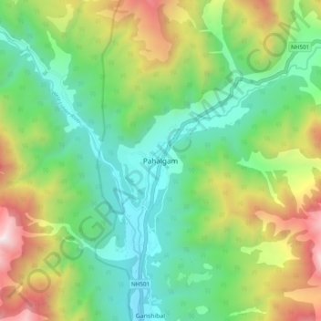
Nom : Carte topographique Pahalgam, altitude, relief.
Lieu : Pahalgam, Anantnag, Jammu and Kashmir, 192126, India (33.99220 75.28265 34.07220 75.36265)
Altitude moyenne : 2.700 m
Altitude minimum : 2.082 m
Altitude maximum : 3.909 m
Faire un don
Équipez-vous pour votre prochaine aventure :
En tant que Partenaire Amazon, ce site perçoit une commission sur les achats éligibles sans surcoût pour vous.