
Faire un don
Équipez-vous pour votre prochaine aventure :
En tant que Partenaire Amazon, ce site perçoit une commission sur les achats éligibles sans surcoût pour vous.
Carte topographique Mt. Hayachine
Cliquez sur la carte pour afficher l’altitude.
Faire un don
Équipez-vous pour votre prochaine aventure :
En tant que Partenaire Amazon, ce site perçoit une commission sur les achats éligibles sans surcoût pour vous.
Mt. Hayachine
Mount Hayachine (早池峰山, Hayachine-san) is the highest mountain in the Kitakami Range, located in the Tōhoku region of northern Honshū, Japan. With an elevation of 1,917 m (6,289 ft), it is the second highest in Iwate Prefecture after Mount Iwate. Mount Hayachine is mentioned in 100 Famous Japanese Mountains, a book written in 1964 by Kyūya Fukada. The mountain is on the borders of the municipalities of Hanamaki, Tōno, and Miyako, east of the prefectural capital of Morioka.
Faire un don
Équipez-vous pour votre prochaine aventure :
En tant que Partenaire Amazon, ce site perçoit une commission sur les achats éligibles sans surcoût pour vous.
À propos de cette carte
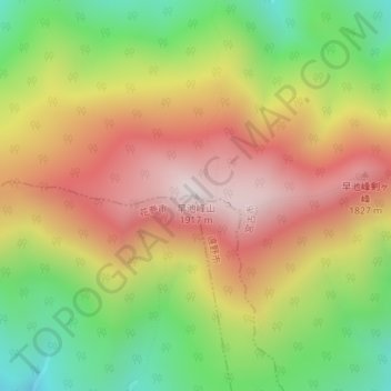
Nom : Carte topographique Mt. Hayachine, altitude, relief.
Lieu : Mt. Hayachine, Miyako, Iwate Prefecture, Japan (39.55832 141.48897 39.55842 141.48907)
Altitude moyenne : 1.490 m
Altitude minimum : 1.062 m
Altitude maximum : 1.904 m
Faire un don
Équipez-vous pour votre prochaine aventure :
En tant que Partenaire Amazon, ce site perçoit une commission sur les achats éligibles sans surcoût pour vous.