
Faire un don
Équipez-vous pour votre prochaine aventure :
En tant que Partenaire Amazon, ce site perçoit une commission sur les achats éligibles sans surcoût pour vous.
Carte topographique Oxford
Cliquez sur la carte pour afficher l’altitude.
Faire un don
Équipez-vous pour votre prochaine aventure :
En tant que Partenaire Amazon, ce site perçoit une commission sur les achats éligibles sans surcoût pour vous.
Oxford
The city is located in the North Central Hills region of Mississippi. The region is known for its heavily forested hills made up of red clay. The area is higher and greater in relief than areas to the west (such as the Mississippi Delta or loess bluffs along the Delta), but lower in elevation than areas in northeast Mississippi. The changes in elevation can be noticed when traveling on the Highway 6 bypass, since the east-west highway tends to transect many of the north-south ridges. Downtown Oxford sits on one of these ridges and the University of Mississippi sits on another one, while the main commercial corridors on either side of the city sit in valleys.
Faire un don
Équipez-vous pour votre prochaine aventure :
En tant que Partenaire Amazon, ce site perçoit une commission sur les achats éligibles sans surcoût pour vous.
À propos de cette carte
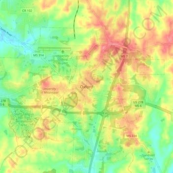
Nom : Carte topographique Oxford, altitude, relief.
Altitude moyenne : 137 m
Altitude minimum : 99 m
Altitude maximum : 178 m
Faire un don
Équipez-vous pour votre prochaine aventure :
En tant que Partenaire Amazon, ce site perçoit une commission sur les achats éligibles sans surcoût pour vous.