
Carte topographique Isla London
Carte interactive
Cliquez sur la carte pour afficher l’altitude.
À propos de cette carte
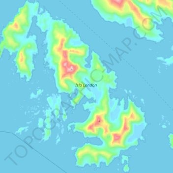
Nom : Carte topographique Isla London, altitude, relief.
Altitude moyenne : 56 m
Altitude minimum : -4 m
Altitude maximum : 644 m
Autres cartes topographiques
Cliquez sur une carte pour visualiser sa topographie, son altitude et son relief.
Kap Hoorn
Chile > XII Region von Magellan und der chilenischen Antarktis > Kap Hoorn
Kap Hoorn, Provinz der chilenischen Antarktis, XII Region von Magellan und der chilenischen Antarktis, Chile
Altitude moyenne : 39 m