
Carte topographique Biggar
Carte interactive
Cliquez sur la carte pour afficher l’altitude.
À propos de cette carte
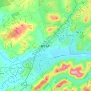
Nom : Carte topographique Biggar, altitude, relief.
Lieu : Biggar, South Lanarkshire, Scotland, ML12 6AE, United Kingdom (55.58449 -3.56158 55.66449 -3.48158)
Altitude moyenne : 254 m
Altitude minimum : 193 m
Altitude maximum : 431 m
Autres cartes topographiques
Cliquez sur une carte pour visualiser sa topographie, son altitude et son relief.
Larkhall
United Kingdom > Scotland > South Lanarkshire
Larkhall, South Lanarkshire, Scotland, ML9 1DR, United Kingdom
Altitude moyenne : 114 m
Bothwell
United Kingdom > Scotland > South Lanarkshire
Bothwell, South Lanarkshire, Scotland, G71 8RB, United Kingdom
Altitude moyenne : 65 m
East Kilbride
United Kingdom > Scotland > South Lanarkshire
East Kilbride, South Lanarkshire, Scotland, G74 1JT, United Kingdom
Altitude moyenne : 175 m
Lanark
United Kingdom > Scotland > South Lanarkshire
Lanark, South Lanarkshire, Scotland, ML11 7EX, United Kingdom
Altitude moyenne : 206 m