
Carte topographique Palatine Hill
Carte interactive
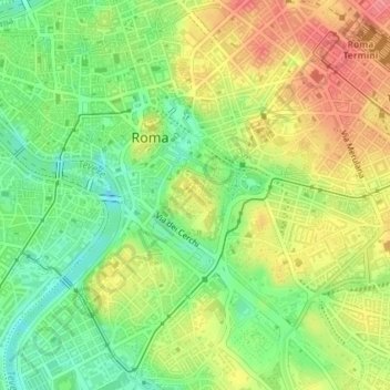
Cliquez sur la carte pour afficher l’altitude.
À propos de cette carte
Nom : Carte topographique Palatine Hill, altitude, relief.
Altitude moyenne : 40 m
Altitude minimum : 3 m
Altitude maximum : 79 m
In 2007 the legendary Lupercal cave was claimed to have been found beneath the remains of the Domus Livia (House of Livia) on the Palatine. Archaeologists came across the 16-metre-deep cavity while restoring the decaying palace, with a richly decorated vault encrusted with mosaics and seashells. The Lupercal was probably converted to a sanctuary by Romans in later centuries. Many Others have denied its identification with the Lupercal on topographic and stylistic grounds, and believe that the grotto is actually a nymphaeum or underground triclinium from Neronian times.
Autres cartes topographiques
Cliquez sur une carte pour visualiser sa topographie, son altitude et son relief.
Fioranello
Italy > Lazio > Roma Capitale > Rome
Fioranello, Municipio Roma VIII, Rome, Roma Capitale, Lazio, 00043, Italy
Altitude moyenne : 105 m
Parco del Colle Oppio
Italy > Lazio > Roma Capitale > Rome
Parco del Colle Oppio, Municipio Roma I, Rome, Roma Capitale, Lazio, Italy
Altitude moyenne : 48 m
Fontignani
Italy > Lazio > Roma Capitale > Rome
Fontignani, Rome, Roma Capitale, Lazio, Italy
Altitude moyenne : 36 m
Parco degli Acquedotti
Italy > Lazio > Roma Capitale > Rome > Osteria del Curato
Parco degli Acquedotti, Osteria del Curato, Rome, Roma Capitale, Lazio, Italy
Altitude moyenne : 62 m
Parco della Caffarella
Italy > Lazio > Roma Capitale > Rome
Parco della Caffarella, Rome, Roma Capitale, Lazio, Italy
Altitude moyenne : 43 m
Parco Eros Corizza
Italy > Lazio > Roma Capitale > Rome
Parco Eros Corizza, Fonte Ostiense, Municipio Roma IX, Rome, Roma Capitale, Lazio, Italy
Altitude moyenne : 36 m
Monte Mario
Italy > Lazio > Roma Capitale > Rome
Monte Mario, Rome, Roma Capitale, Lazio, 00100, Italy
Altitude moyenne : 65 m
Giardini del Quirinale
Italy > Lazio > Roma Capitale > Rome
Giardini del Quirinale, Trevi, Municipio Roma I, Rome, Roma Capitale, Lazio, Italy
Altitude moyenne : 49 m