
Carte topographique Dublin Castle
Carte interactive
Cliquez sur la carte pour afficher l’altitude.
À propos de cette carte
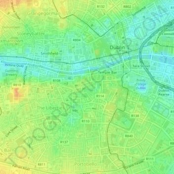
Nom : Carte topographique Dublin Castle, altitude, relief.
Altitude moyenne : 16 m
Altitude minimum : 1 m
Altitude maximum : 32 m
The Poddle was diverted into the city through archways where the walls adjoined the castle, artificially flooding the moat of the fortress's city elevations. One of these archways and part of the wall survive buried underneath the 18th-century buildings, and are open for public viewing.
Autres cartes topographiques
Cliquez sur une carte pour visualiser sa topographie, son altitude et son relief.
Priorswood
Ireland > County Dublin > Dublin
Priorswood, Priorswood E Ward 1986, Dublin, County Dublin, Leinster, D17 XV48, Ireland
Altitude moyenne : 42 m
Liberty of Donore
Ireland > County Dublin > Dublin
Liberty of Donore, Kimmage C Ward 1986, Dublin, County Dublin, Leinster, Ireland
Altitude moyenne : 27 m
Darndale
Ireland > County Dublin > Dublin
Darndale, Priorswood C Ward 1986, Dublin, County Dublin, Leinster, Ireland
Altitude moyenne : 35 m
Bluebell
Ireland > County Dublin > Dublin
Bluebell, Inchicore B Ward 1986, Dublin, County Dublin, Leinster, Ireland
Altitude moyenne : 44 m
Ballygall
Ireland > County Dublin > Dublin
Ballygall, Finglas East D ED, Dublin, County Dublin, Leinster, Ireland
Altitude moyenne : 53 m
Dublin
Ireland > County Dublin > Dublin
Dublin, Dún Laoghaire-Rathdown, County Dublin, Leinster, Ireland
Altitude moyenne : 23 m
Sandymount
Ireland > County Dublin > Dublin
Sandymount, Pembroke East C ED, Dublin, County Dublin, Leinster, Ireland
Altitude moyenne : 5 m
Santry
Ireland > County Dublin > Dublin
Santry, Whitehall C ED, Dublin, County Dublin, Leinster, Ireland
Altitude moyenne : 54 m
Glasnevin
Ireland > County Dublin > Dublin
Glasnevin, Glasnevin A ED, Dublin, County Dublin, Leinster, D09 YN97, Ireland
Altitude moyenne : 33 m
North Bull Island
Ireland > County Dublin > Dublin
North Bull Island, Raheny St. Assam ED, Dublin, County Dublin, Leinster, Ireland
Altitude moyenne : 2 m
Rathgar
Ireland > County Dublin > Dublin
Rathgar, Rathfarnham A ED, Dublin, County Dublin, Leinster, Ireland
Altitude moyenne : 40 m
Santry
Ireland > County Dublin > Dublin
Santry, Dublin, Fingal, County Dublin, Leinster, Ireland
Altitude moyenne : 49 m
Belcamp
Ireland > County Dublin > Dublin
Belcamp, Priorswood B ED, Dublin, County Dublin, Leinster, Ireland
Altitude moyenne : 37 m
Clonmel
Ireland > County Dublin > Dublin
Clonmel, Ballymun E ED, Dublin, County Dublin, Leinster, Ireland
Altitude moyenne : 57 m
Rathmines
Ireland > County Dublin > Dublin
Rathmines, Rathmines West B ED, Dublin, County Dublin, Leinster, Ireland
Altitude moyenne : 28 m
Walkinstown
Ireland > County Dublin > Dublin
Walkinstown, Walkinstown B Ward 1986, Dublin, County Dublin, Leinster, Ireland
Altitude moyenne : 49 m
Donnycarney
Ireland > County Dublin > Dublin
Donnycarney, Drumcondra North A ED, Dublin, County Dublin, Leinster, Ireland
Altitude moyenne : 24 m
Terenure
Ireland > County Dublin > Dublin
Terenure, Rathfarnham A ED, Dublin, County Dublin, Leinster, D06 K767, Ireland
Altitude moyenne : 45 m
Irishtown
Ireland > County Dublin > Dublin
Irishtown, Pembroke East A ED, Dublin, County Dublin, Leinster, Ireland
Altitude moyenne : 5 m