
Faire un don
Équipez-vous pour votre prochaine aventure :
En tant que Partenaire Amazon, ce site perçoit une commission sur les achats éligibles sans surcoût pour vous.
Carte topographique Furley
Cliquez sur la carte pour afficher l’altitude.
Faire un don
Équipez-vous pour votre prochaine aventure :
En tant que Partenaire Amazon, ce site perçoit une commission sur les achats éligibles sans surcoût pour vous.
À propos de cette carte
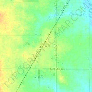
Nom : Carte topographique Furley, altitude, relief.
Lieu : Furley, Sedgwick County, Kansas, United States (37.85918 -97.23282 37.89918 -97.19282)
Altitude moyenne : 426 m
Altitude minimum : 410 m
Altitude maximum : 443 m
Faire un don
Équipez-vous pour votre prochaine aventure :
En tant que Partenaire Amazon, ce site perçoit une commission sur les achats éligibles sans surcoût pour vous.
Autres cartes topographiques
Cliquez sur une carte pour visualiser sa topographie, son altitude et son relief.
Wichita
United States > Kansas > Sedgwick County
Wichita features a predominantly flat and gently rolling landscape characteristic of the Great Plains region. The city sits at an elevation of approximately 1,300 feet above sea level and is crisscrossed by several small rivers, including the Arkansas River, which flows through the city, providing a slight…
Altitude moyenne : 408 m
Faire un don
Équipez-vous pour votre prochaine aventure :
En tant que Partenaire Amazon, ce site perçoit une commission sur les achats éligibles sans surcoût pour vous.
Goddard
United States > Kansas > Sedgwick County
Goddard is located at 37°39′35″N 97°34′27″W / 37.65972°N 97.57417°W / 37.65972; -97.57417 (37.659706, -97.574271) at an elevation of 1,463 feet (446 m). Goddard lies on U.S. Route 54 in south-central Kansas, immediately west of Wichita.
Altitude moyenne : 443 m
Wichita
United States > Kansas > Sedgwick County
The city lies on the Arkansas River near the western edge of the Flint Hills in the Wellington-McPherson Lowlands region of the Great Plains. The area's topography is characterized by the broad alluvial plain of the Arkansas River valley and the moderately rolling slopes that rise to the higher lands on either…
Altitude moyenne : 408 m
Faire un don
Équipez-vous pour votre prochaine aventure :
En tant que Partenaire Amazon, ce site perçoit une commission sur les achats éligibles sans surcoût pour vous.
Wichita
United States > Kansas > Sedgwick County
The city lies on the Arkansas River near the western edge of the Flint Hills in the Wellington-McPherson Lowlands region of the Great Plains. The area's topography is characterized by the broad alluvial plain of the Arkansas River valley and the moderately rolling slopes that rise to the higher lands on either…
Altitude moyenne : 408 m
Faire un don
Équipez-vous pour votre prochaine aventure :
En tant que Partenaire Amazon, ce site perçoit une commission sur les achats éligibles sans surcoût pour vous.
Wichita
United States > Kansas > Sedgwick County
The city lies on the Arkansas River near the western edge of the Flint Hills in the Wellington-McPherson Lowlands region of the Great Plains. The area's topography is characterized by the broad alluvial plain of the Arkansas River valley and the moderately rolling slopes that rise to the higher lands on either…
Altitude moyenne : 408 m
Wichita
United States > Kansas > Sedgwick County
The city lies on the Arkansas River near the western edge of the Flint Hills in the Wellington-McPherson Lowlands region of the Great Plains. The area's topography is characterized by the broad alluvial plain of the Arkansas River valley and the moderately rolling slopes that rise to the higher lands on either…
Altitude moyenne : 408 m
Faire un don
Équipez-vous pour votre prochaine aventure :
En tant que Partenaire Amazon, ce site perçoit une commission sur les achats éligibles sans surcoût pour vous.
Faire un don
Équipez-vous pour votre prochaine aventure :
En tant que Partenaire Amazon, ce site perçoit une commission sur les achats éligibles sans surcoût pour vous.