
Faire un don
Équipez-vous pour votre prochaine aventure :
En tant que Partenaire Amazon, ce site perçoit une commission sur les achats éligibles sans surcoût pour vous.
Carte topographique Surajpur
Cliquez sur la carte pour afficher l’altitude.
Faire un don
Équipez-vous pour votre prochaine aventure :
En tant que Partenaire Amazon, ce site perçoit une commission sur les achats éligibles sans surcoût pour vous.
Surajpur
Due to its mountainous topography, the district largely escaped the turmoil of the surrounding plains. The earliest inhabitants are said to be the Kols and Gonds, but there is evidence of more widespread civilization in the region. The rulers of Surguja State were Raksel Rajputs, and were said to have originally ruled Palamu. However in 1613 CE, while Man Singh was in Surguja to celebrate his son's wedding with the daughter of the local ruler, the Cheros, led by Bhagwant Rai, killed the then-ruler Man Singh's family and took over Palamu. Man Singh subsequently killed the chief of Surguja and took over his state. Other sources state that the Raksel dynasty gained overlordship over the various petty chieftancies of the region and exercised hegemony over the other states including Koriya and Changbhakar.
Faire un don
Équipez-vous pour votre prochaine aventure :
En tant que Partenaire Amazon, ce site perçoit une commission sur les achats éligibles sans surcoût pour vous.
À propos de cette carte
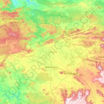
Nom : Carte topographique Surajpur, altitude, relief.
Lieu : Surajpur, Chhattisgarh, India (22.79547 82.49750 23.92068 83.36718)
Altitude moyenne : 571 m
Altitude minimum : 305 m
Altitude maximum : 1.161 m
Faire un don
Équipez-vous pour votre prochaine aventure :
En tant que Partenaire Amazon, ce site perçoit une commission sur les achats éligibles sans surcoût pour vous.
Autres cartes topographiques
Cliquez sur une carte pour visualiser sa topographie, son altitude et son relief.
Faire un don
Équipez-vous pour votre prochaine aventure :
En tant que Partenaire Amazon, ce site perçoit une commission sur les achats éligibles sans surcoût pour vous.
Raigarh
India > Chhattisgarh > Raigarh Tahsil
Raigarh is located at 21°54′N 83°24′E / 21.9°N 83.4°E / 21.9; 83.4. It has an average elevation of 215 metres (705 feet). The Kelo river flows through the city, which is one of its main water sources.
Altitude moyenne : 216 m
veterinary hospital vilvattom
India > Chhattisgarh > Jaijaipur Tahsil > Bawanbadi
Altitude moyenne : 236 m
Faire un don
Équipez-vous pour votre prochaine aventure :
En tant que Partenaire Amazon, ce site perçoit une commission sur les achats éligibles sans surcoût pour vous.
Faire un don
Équipez-vous pour votre prochaine aventure :
En tant que Partenaire Amazon, ce site perçoit une commission sur les achats éligibles sans surcoût pour vous.
Faire un don
Équipez-vous pour votre prochaine aventure :
En tant que Partenaire Amazon, ce site perçoit une commission sur les achats éligibles sans surcoût pour vous.
Faire un don
Équipez-vous pour votre prochaine aventure :
En tant que Partenaire Amazon, ce site perçoit une commission sur les achats éligibles sans surcoût pour vous.
Faire un don
Équipez-vous pour votre prochaine aventure :
En tant que Partenaire Amazon, ce site perçoit une commission sur les achats éligibles sans surcoût pour vous.
Balodabazar
India > Chhattisgarh > Baloda Bazar Tahsil
Baloda Bazar is located at 30°40′N 82°10′E / 30.67°N 82.17°E / 30.67; 82.17. It has an average elevation of 254 m (833 ft). There are several tourist places in Balodabazaar like Sirpur, Turturia, Giroudpuri, Siddheswr Mandir Pallari and many more.
Altitude moyenne : 251 m
Rajim
India > Chhattisgarh > Rajim Tahsil
It is located at an elevation of 281 m above MSL.
Altitude moyenne : 286 m
Faire un don
Équipez-vous pour votre prochaine aventure :
En tant que Partenaire Amazon, ce site perçoit une commission sur les achats éligibles sans surcoût pour vous.
Kirandul
India > Chhattisgarh > Kuakonda Tahsil
The Kothavalasa–Kirandul line of East Coast Railway from Kirandul to Visakhapatnam via Koraput is laid through the Eastern Ghats. Up to Araku station, it has many tunnels. Also it pass through the highest elevation Broad gauge station in the Eastern ghats, Semiliguda, just before the Borra caves. Kirandul -…
Altitude moyenne : 742 m
Kawardha
India > Chhattisgarh > Kawardha Tahsil
Kawardha is located at 22°01′N 81°15′E / 22.02°N 81.25°E / 22.02; 81.25. The total area is 798 square miles (2,070 km2). The state consists of hills and forests. It has an average elevation of 353 metres (1,158 ft).
Altitude moyenne : 350 m
Faire un don
Équipez-vous pour votre prochaine aventure :
En tant que Partenaire Amazon, ce site perçoit une commission sur les achats éligibles sans surcoût pour vous.
Faire un don
Équipez-vous pour votre prochaine aventure :
En tant que Partenaire Amazon, ce site perçoit une commission sur les achats éligibles sans surcoût pour vous.
Pendra
India > Chhattisgarh > Pendra Tahsil
Pendra has an average elevation of 617 metres (2,024 ft).
Altitude moyenne : 594 m
Faire un don
Équipez-vous pour votre prochaine aventure :
En tant que Partenaire Amazon, ce site perçoit une commission sur les achats éligibles sans surcoût pour vous.
Surajpur
India > Chhattisgarh > Surajpur Tahsil
Surajpur is located at 23°13′N 82°51′E / 23.22°N 82.85°E / 23.22; 82.85. It has an average elevation of 528 metres (1,732 ft).
Altitude moyenne : 541 m
Faire un don
Équipez-vous pour votre prochaine aventure :
En tant que Partenaire Amazon, ce site perçoit une commission sur les achats éligibles sans surcoût pour vous.
Sukma
India > Chhattisgarh > Sukma Tahsil
It is located at 18°24′0″N 81°40′0″E / 18.40000°N 81.66667°E / 18.40000; 81.66667 at an elevation of 210 m above MSL.
Altitude moyenne : 219 m