
Carte topographique Querétaro
Carte interactive
Cliquez sur la carte pour afficher l’altitude.
À propos de cette carte
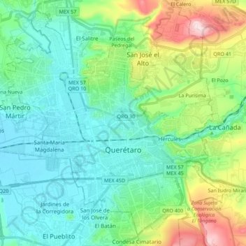
Nom : Carte topographique Querétaro, altitude, relief.
Lieu : Querétaro, Municipio de Querétaro, Querétaro, Mexico (20.54031 -100.48015 20.68397 -100.31196)
Altitude moyenne : 1.921 m
Altitude minimum : 1.795 m
Altitude maximum : 2.316 m
The municipality has rolling hills, mountain ranges and flatlands. Most of the rolling hills cross the territory from south to north, paralleling the Querétaro-San Luis Potosí highway. Most plains are located in the north, and are of sedimentary soil with some protrusions of volcanic rock. Altitude varies from 1,900 to 2,460 meters above sea level with the highest elevations at mountains called El Buey, Pie de Gallo, El Patol, El Nabo, and El Paisano. The city proper is on a plain at 1,900 meters. There is only one river, the Querétaro River, which carved the La Cañada. There are numerous streams, many of them seasonal, and fresh water springs near the mountain areas. The territory contains deposits of gold, silver, manganese, tin, mercury, lead, zinc, opal, quartz, cantera stone (for building) among other minerals.
Autres cartes topographiques
Cliquez sur une carte pour visualiser sa topographie, son altitude et son relief.
Juriquilla
Mexico > Querétaro > Municipio de Querétaro
Juriquilla, Municipio de Querétaro, Querétaro, Mexico
Altitude moyenne : 1.924 m
La Estacada
Mexico > Querétaro > Municipio de Querétaro
La Estacada, Municipio de Querétaro, Querétaro, 67230, Mexico
Altitude moyenne : 2.086 m
Delegación Josefa Vergara y Hernández
Mexico > Querétaro > Municipio de Querétaro
Delegación Josefa Vergara y Hernández, Municipio de Querétaro, Querétaro, Mexico
Altitude moyenne : 1.958 m